You are here: Home > Network List > RV - Regional Alberta Seismic Observatory for Earthquake Studies Network Stations List
> Station LGPLA Lodgepole, Alberta > Earthquake Result Viewer
LGPLA Lodgepole, Alberta - Earthquake Result Viewer
| Earthquake location: |
Kamchatka Peninsula, Russia |
| Earthquake latitude/longitude: |
54.0/158.5 |
| Earthquake time(UTC): |
2016/01/30 (030) 03:25:10 GMT |
| Earthquake Depth: |
161 km |
| Earthquake Magnitude: |
7.2 MWW, 7.0 MI, 7.2 MWB |
| Earthquake Catalog/Contributor: |
NEIC PDE/NEIC COMCAT |
|
| Network: |
RV Regional Alberta Seismic Observatory for Earthquake Studies Network |
| Station: |
LGPLA Lodgepole, Alberta |
| Lat/Lon: |
53.12 N/115.36 W |
| Elevation: |
877 m |
|
| Distance: |
48.1 deg |
| Az: |
53.92 deg |
| Baz: |
307.679 deg |
| Ray Param: |
0.06899958 |
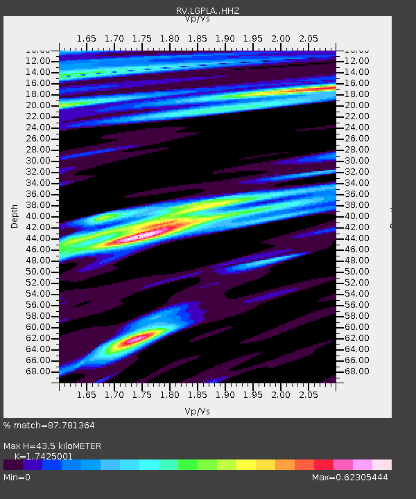
| Estimated Moho Depth: |
43.5 km |
| Estimated Crust Vp/Vs: |
1.74 |
| Assumed Crust Vp: |
6.426 km/s |
| Estimated Crust Vs: |
3.688 km/s |
| Estimated Crust Poisson's Ratio: |
0.25 |
|
| Radial Match: |
87.781364 % |
| Radial Bump: |
400 |
| Transverse Match: |
72.89928 % |
| Transverse Bump: |
400 |
| SOD ConfigId: |
7422571 |
| Insert Time: |
2019-04-21 20:44:13.977 +0000 |
| GWidth: |
2.5 |
| Max Bumps: |
400 |
| Tol: |
0.001 |
|

Signal To Noise
| Channel | StoN | STA | LTA |
| RV:LGPLA: :HHZ:20160130T03:33:03.259996Z | 48.106476 | 2.1877066E-5 | 4.5476344E-7 |
| RV:LGPLA: :HHN:20160130T03:33:03.259996Z | 3.916409 | 5.5841147E-6 | 1.4258252E-6 |
| RV:LGPLA: :HHE:20160130T03:33:03.259996Z | 8.810067 | 7.5586645E-6 | 8.579576E-7 |
| Arrivals |
| Ps | 5.3 SECOND |
| PpPs | 17 SECOND |
| PsPs/PpSs | 23 SECOND |


