You are here: Home > Network List > RV - Regional Alberta Seismic Observatory for Earthquake Studies Network Stations List
> Station MANA Manning, AB > Earthquake Result Viewer
MANA Manning, AB - Earthquake Result Viewer
| Earthquake location: |
Kamchatka Peninsula, Russia |
| Earthquake latitude/longitude: |
54.0/158.5 |
| Earthquake time(UTC): |
2016/01/30 (030) 03:25:10 GMT |
| Earthquake Depth: |
161 km |
| Earthquake Magnitude: |
7.2 MWW, 7.0 MI, 7.2 MWB |
| Earthquake Catalog/Contributor: |
NEIC PDE/NEIC COMCAT |
|
| Network: |
RV Regional Alberta Seismic Observatory for Earthquake Studies Network |
| Station: |
MANA Manning, AB |
| Lat/Lon: |
56.86 N/117.64 W |
| Elevation: |
480 m |
|
| Distance: |
44.8 deg |
| Az: |
50.779 deg |
| Baz: |
303.649 deg |
| Ray Param: |
0.07106184 |
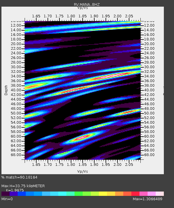
| Estimated Moho Depth: |
33.75 km |
| Estimated Crust Vp/Vs: |
1.97 |
| Assumed Crust Vp: |
6.444 km/s |
| Estimated Crust Vs: |
3.275 km/s |
| Estimated Crust Poisson's Ratio: |
0.33 |
|
| Radial Match: |
90.18164 % |
| Radial Bump: |
400 |
| Transverse Match: |
73.74394 % |
| Transverse Bump: |
400 |
| SOD ConfigId: |
7422571 |
| Insert Time: |
2019-04-21 20:44:14.760 +0000 |
| GWidth: |
2.5 |
| Max Bumps: |
400 |
| Tol: |
0.001 |
|

Signal To Noise
| Channel | StoN | STA | LTA |
| RV:MANA: :BHZ:20160130T03:32:37.969988Z | 32.600113 | 2.1282223E-5 | 6.5282666E-7 |
| RV:MANA: :BHN:20160130T03:32:37.969988Z | 8.001857 | 9.698021E-6 | 1.2119714E-6 |
| RV:MANA: :BHE:20160130T03:32:37.969988Z | 12.949918 | 1.1877038E-5 | 9.171516E-7 |
| Arrivals |
| Ps | 5.4 SECOND |
| PpPs | 15 SECOND |
| PsPs/PpSs | 20 SECOND |


