You are here: Home > Network List > SV - Servicio Nacional de Estudios Territoriales (SNET), El Salvador Stations List
> Station MTO3 Montecristo > Earthquake Result Viewer
MTO3 Montecristo - Earthquake Result Viewer
| Earthquake location: |
Kamchatka Peninsula, Russia |
| Earthquake latitude/longitude: |
54.0/158.5 |
| Earthquake time(UTC): |
2016/01/30 (030) 03:25:10 GMT |
| Earthquake Depth: |
161 km |
| Earthquake Magnitude: |
7.2 MWW, 7.0 MI, 7.2 MWB |
| Earthquake Catalog/Contributor: |
NEIC PDE/NEIC COMCAT |
|
| Network: |
SV Servicio Nacional de Estudios Territoriales (SNET), El Salvador |
| Station: |
MTO3 Montecristo |
| Lat/Lon: |
14.40 N/89.36 W |
| Elevation: |
1830 m |
|
| Distance: |
90.9 deg |
| Az: |
63.857 deg |
| Baz: |
326.849 deg |
| Ray Param: |
0.041605033 |
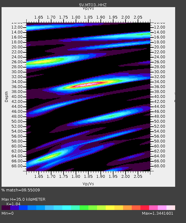
| Estimated Moho Depth: |
35.0 km |
| Estimated Crust Vp/Vs: |
1.84 |
| Assumed Crust Vp: |
6.597 km/s |
| Estimated Crust Vs: |
3.586 km/s |
| Estimated Crust Poisson's Ratio: |
0.29 |
|
| Radial Match: |
89.55009 % |
| Radial Bump: |
400 |
| Transverse Match: |
85.53384 % |
| Transverse Bump: |
400 |
| SOD ConfigId: |
7422571 |
| Insert Time: |
2019-04-21 20:44:46.195 +0000 |
| GWidth: |
2.5 |
| Max Bumps: |
400 |
| Tol: |
0.001 |
|

Signal To Noise
| Channel | StoN | STA | LTA |
| SV:MTO3: :HHZ:20160130T03:37:24.667986Z | 28.910728 | 5.1726815E-6 | 1.7891911E-7 |
| SV:MTO3: :HHN:20160130T03:37:24.667986Z | 10.176034 | 1.2752871E-6 | 1.2532261E-7 |
| SV:MTO3: :HHE:20160130T03:37:24.667986Z | 7.9844174 | 1.3477703E-6 | 1.6880007E-7 |
| Arrivals |
| Ps | 4.6 SECOND |
| PpPs | 15 SECOND |
| PsPs/PpSs | 19 SECOND |


