You are here: Home > Network List > TA - USArray Transportable Network (new EarthScope stations) Stations List
> Station KMSC Kings Mountain, Blacksburg, SC, USA > Earthquake Result Viewer
KMSC Kings Mountain, Blacksburg, SC, USA - Earthquake Result Viewer
| Earthquake location: |
Kamchatka Peninsula, Russia |
| Earthquake latitude/longitude: |
54.0/158.5 |
| Earthquake time(UTC): |
2016/01/30 (030) 03:25:10 GMT |
| Earthquake Depth: |
161 km |
| Earthquake Magnitude: |
7.2 MWW, 7.0 MI, 7.2 MWB |
| Earthquake Catalog/Contributor: |
NEIC PDE/NEIC COMCAT |
|
| Network: |
TA USArray Transportable Network (new EarthScope stations) |
| Station: |
KMSC Kings Mountain, Blacksburg, SC, USA |
| Lat/Lon: |
35.14 N/81.33 W |
| Elevation: |
240 m |
|
| Distance: |
77.3 deg |
| Az: |
46.578 deg |
| Baz: |
328.458 deg |
| Ray Param: |
0.050000213 |
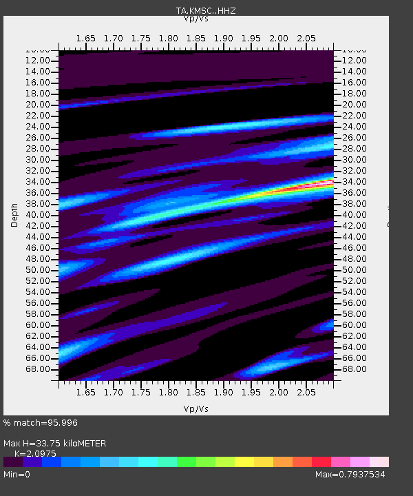
| Estimated Moho Depth: |
33.75 km |
| Estimated Crust Vp/Vs: |
2.10 |
| Assumed Crust Vp: |
6.419 km/s |
| Estimated Crust Vs: |
3.06 km/s |
| Estimated Crust Poisson's Ratio: |
0.35 |
|
| Radial Match: |
95.996 % |
| Radial Bump: |
280 |
| Transverse Match: |
78.62567 % |
| Transverse Bump: |
400 |
| SOD ConfigId: |
7422571 |
| Insert Time: |
2019-04-21 20:45:19.523 +0000 |
| GWidth: |
2.5 |
| Max Bumps: |
400 |
| Tol: |
0.001 |
|

Signal To Noise
| Channel | StoN | STA | LTA |
| TA:KMSC: :HHZ:20160130T03:36:16.229998Z | 15.135345 | 1.141121E-5 | 7.539445E-7 |
| TA:KMSC: :HHN:20160130T03:36:16.229998Z | 12.076717 | 4.6353985E-6 | 3.838293E-7 |
| TA:KMSC: :HHE:20160130T03:36:16.229998Z | 10.117971 | 3.1292466E-6 | 3.092761E-7 |
| Arrivals |
| Ps | 5.9 SECOND |
| PpPs | 16 SECOND |
| PsPs/PpSs | 22 SECOND |


