You are here: Home > Network List > TA - USArray Transportable Network (new EarthScope stations) Stations List
> Station K22A Casper, WY, USA > Earthquake Result Viewer
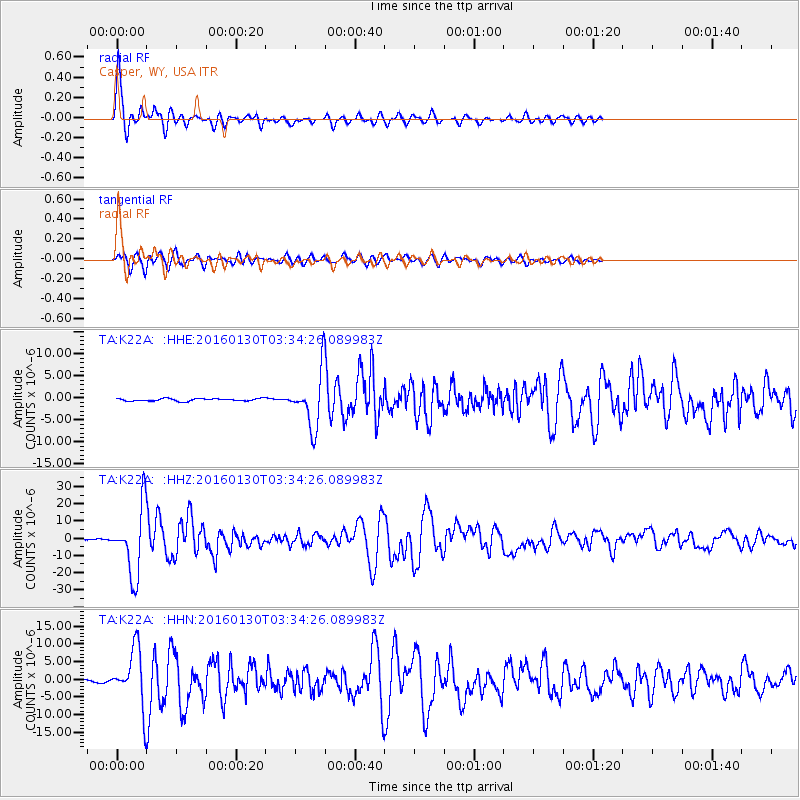
K22A Casper, WY, USA - Earthquake Result Viewer
| Earthquake location: |
Kamchatka Peninsula, Russia |
| Earthquake latitude/longitude: |
54.0/158.5 |
| Earthquake time(UTC): |
2016/01/30 (030) 03:25:10 GMT |
| Earthquake Depth: |
161 km |
| Earthquake Magnitude: |
7.2 MWW, 7.0 MI, 7.2 MWB |
| Earthquake Catalog/Contributor: |
NEIC PDE/NEIC COMCAT |
|
| Network: |
TA USArray Transportable Network (new EarthScope stations) |
| Station: |
K22A Casper, WY, USA |
| Lat/Lon: |
42.65 N/106.52 W |
| Elevation: |
1686 m |
|
| Distance: |
59.5 deg |
| Az: |
58.519 deg |
| Baz: |
316.974 deg |
| Ray Param: |
0.061629992 |
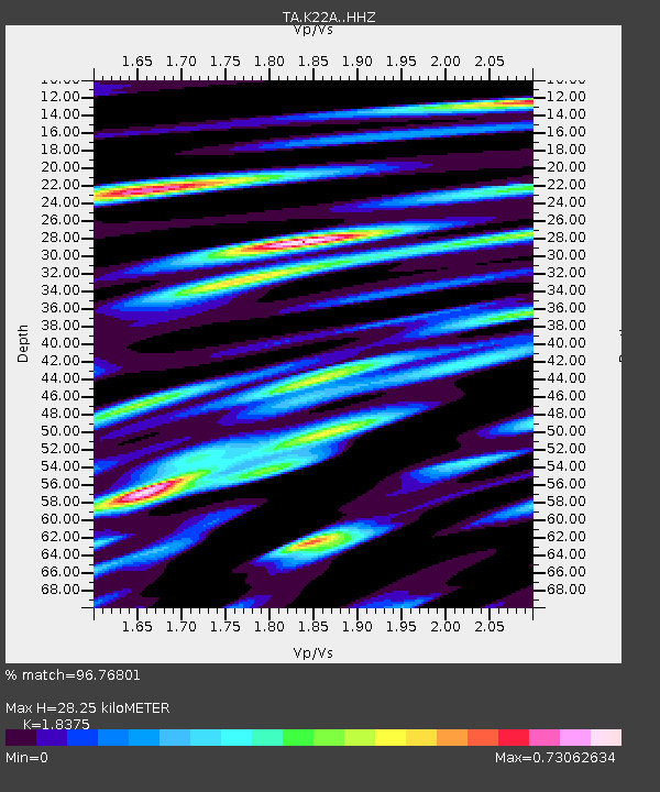
| Estimated Moho Depth: |
28.25 km |
| Estimated Crust Vp/Vs: |
1.84 |
| Assumed Crust Vp: |
6.178 km/s |
| Estimated Crust Vs: |
3.362 km/s |
| Estimated Crust Poisson's Ratio: |
0.29 |
|
| Radial Match: |
96.76801 % |
| Radial Bump: |
373 |
| Transverse Match: |
89.47174 % |
| Transverse Bump: |
400 |
| SOD ConfigId: |
7422571 |
| Insert Time: |
2019-04-21 20:45:19.983 +0000 |
| GWidth: |
2.5 |
| Max Bumps: |
400 |
| Tol: |
0.001 |
|
Signal To Noise
| Channel | StoN | STA | LTA |
| TA:K22A: :HHZ:20160130T03:34:26.089983Z | 73.95681 | 1.9471492E-5 | 2.6328195E-7 |
| TA:K22A: :HHN:20160130T03:34:26.089983Z | 24.518003 | 7.765305E-6 | 3.1671848E-7 |
| TA:K22A: :HHE:20160130T03:34:26.089983Z | 19.812551 | 5.7778034E-6 | 2.916234E-7 |
| Arrivals |
| Ps | 4.0 SECOND |
| PpPs | 12 SECOND |
| PsPs/PpSs | 16 SECOND |


