You are here: Home > Network List > TA - USArray Transportable Network (new EarthScope stations) Stations List
> Station P60A Greenville, DE, USA > Earthquake Result Viewer
P60A Greenville, DE, USA - Earthquake Result Viewer
| Earthquake location: |
Kamchatka Peninsula, Russia |
| Earthquake latitude/longitude: |
54.0/158.5 |
| Earthquake time(UTC): |
2016/01/30 (030) 03:25:10 GMT |
| Earthquake Depth: |
161 km |
| Earthquake Magnitude: |
7.2 MWW, 7.0 MI, 7.2 MWB |
| Earthquake Catalog/Contributor: |
NEIC PDE/NEIC COMCAT |
|
| Network: |
TA USArray Transportable Network (new EarthScope stations) |
| Station: |
P60A Greenville, DE, USA |
| Lat/Lon: |
39.81 N/75.64 W |
| Elevation: |
105 m |
|
| Distance: |
75.6 deg |
| Az: |
40.127 deg |
| Baz: |
330.404 deg |
| Ray Param: |
0.051139478 |
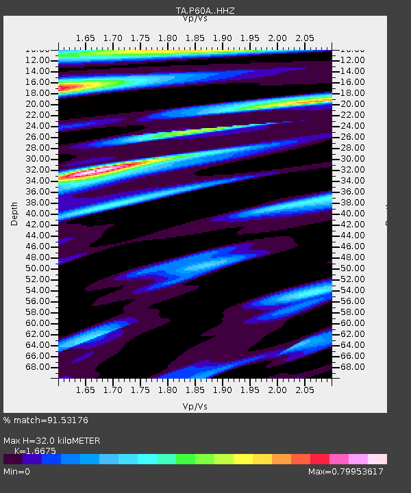
| Estimated Moho Depth: |
32.0 km |
| Estimated Crust Vp/Vs: |
1.67 |
| Assumed Crust Vp: |
6.287 km/s |
| Estimated Crust Vs: |
3.771 km/s |
| Estimated Crust Poisson's Ratio: |
0.22 |
|
| Radial Match: |
91.53176 % |
| Radial Bump: |
350 |
| Transverse Match: |
80.16178 % |
| Transverse Bump: |
400 |
| SOD ConfigId: |
7422571 |
| Insert Time: |
2019-04-21 20:45:46.657 +0000 |
| GWidth: |
2.5 |
| Max Bumps: |
400 |
| Tol: |
0.001 |
|

Signal To Noise
| Channel | StoN | STA | LTA |
| TA:P60A: :HHZ:20160130T03:36:06.68001Z | 24.117294 | 1.4849923E-5 | 6.157375E-7 |
| TA:P60A: :HHN:20160130T03:36:06.68001Z | 8.184264 | 3.950703E-6 | 4.827194E-7 |
| TA:P60A: :HHE:20160130T03:36:06.68001Z | 2.9359705 | 1.6037386E-6 | 5.462379E-7 |
| Arrivals |
| Ps | 3.5 SECOND |
| PpPs | 13 SECOND |
| PsPs/PpSs | 17 SECOND |


