You are here: Home > Network List > US - United States National Seismic Network Stations List
> Station DGMT Dagmar, Montana, USA > Earthquake Result Viewer
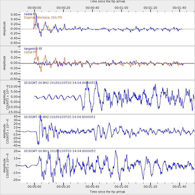
DGMT Dagmar, Montana, USA - Earthquake Result Viewer
*The percent match for this event was below the threshold and hence no stack was calculated.
| Earthquake location: |
Kamchatka Peninsula, Russia |
| Earthquake latitude/longitude: |
54.0/158.5 |
| Earthquake time(UTC): |
2016/01/30 (030) 03:25:10 GMT |
| Earthquake Depth: |
161 km |
| Earthquake Magnitude: |
7.2 MWW, 7.0 MI, 7.2 MWB |
| Earthquake Catalog/Contributor: |
NEIC PDE/NEIC COMCAT |
|
| Network: |
US United States National Seismic Network |
| Station: |
DGMT Dagmar, Montana, USA |
| Lat/Lon: |
48.47 N/104.20 W |
| Elevation: |
0.0 m |
|
| Distance: |
56.5 deg |
| Az: |
52.375 deg |
| Baz: |
315.373 deg |
| Ray Param: |
$rayparam |
*The percent match for this event was below the threshold and hence was not used in the summary stack. |
|
| Radial Match: |
93.86171 % |
| Radial Bump: |
314 |
| Transverse Match: |
78.49761 % |
| Transverse Bump: |
400 |
| SOD ConfigId: |
7422571 |
| Insert Time: |
2019-04-21 20:46:34.522 +0000 |
| GWidth: |
2.5 |
| Max Bumps: |
400 |
| Tol: |
0.001 |
|
Signal To Noise
| Channel | StoN | STA | LTA |
| US:DGMT:00:BHZ:20160130T03:34:04.800005Z | 41.428528 | 2.310295E-5 | 5.57658E-7 |
| US:DGMT:00:BH1:20160130T03:34:04.800005Z | 3.714525 | 5.859868E-6 | 1.5775552E-6 |
| US:DGMT:00:BH2:20160130T03:34:04.800005Z | 4.428139 | 5.5736355E-6 | 1.2586856E-6 |
| Arrivals |
| Ps | |
| PpPs | |
| PsPs/PpSs | |


