You are here: Home > Network List > XD14 - Illuminating the architecture of the greater Mount St. Helens magmatic systems f Stations List
> Station MQ07 "Mount St Helens, WA" > Earthquake Result Viewer
MQ07 "Mount St Helens, WA" - Earthquake Result Viewer
| Earthquake location: |
Kamchatka Peninsula, Russia |
| Earthquake latitude/longitude: |
54.0/158.5 |
| Earthquake time(UTC): |
2016/01/30 (030) 03:25:10 GMT |
| Earthquake Depth: |
161 km |
| Earthquake Magnitude: |
7.2 MWW, 7.0 MI, 7.2 MWB |
| Earthquake Catalog/Contributor: |
NEIC PDE/NEIC COMCAT |
|
| Network: |
XD Illuminating the architecture of the greater Mount St. Helens magmatic systems f |
| Station: |
MQ07 "Mount St Helens, WA" |
| Lat/Lon: |
45.81 N/122.11 W |
| Elevation: |
1037 m |
|
| Distance: |
49.2 deg |
| Az: |
65.187 deg |
| Baz: |
310.005 deg |
| Ray Param: |
0.0682667 |
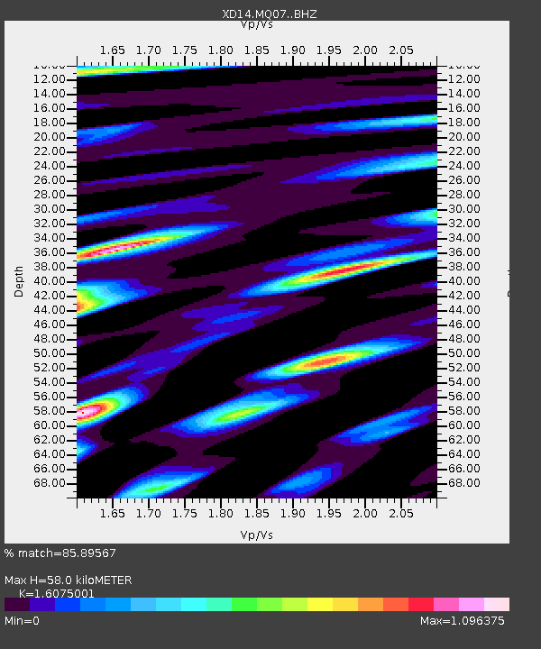
| Estimated Moho Depth: |
58.0 km |
| Estimated Crust Vp/Vs: |
1.61 |
| Assumed Crust Vp: |
6.566 km/s |
| Estimated Crust Vs: |
4.085 km/s |
| Estimated Crust Poisson's Ratio: |
0.18 |
|
| Radial Match: |
85.89567 % |
| Radial Bump: |
400 |
| Transverse Match: |
72.19824 % |
| Transverse Bump: |
400 |
| SOD ConfigId: |
7422571 |
| Insert Time: |
2019-04-21 20:48:21.499 +0000 |
| GWidth: |
2.5 |
| Max Bumps: |
400 |
| Tol: |
0.001 |
|

Signal To Noise
| Channel | StoN | STA | LTA |
| XD:MQ07: :BHZ:20160130T03:33:12.050005Z | 7.6794176 | 8.181192E-6 | 1.0653401E-6 |
| XD:MQ07: :BHN:20160130T03:33:12.050005Z | 4.781711 | 2.3462544E-6 | 4.9067256E-7 |
| XD:MQ07: :BHE:20160130T03:33:12.050005Z | 5.2891226 | 3.6225988E-6 | 6.8491494E-7 |
| Arrivals |
| Ps | 5.7 SECOND |
| PpPs | 22 SECOND |
| PsPs/PpSs | 27 SECOND |


