You are here: Home > Network List > US - United States National Seismic Network Stations List
> Station AMTX Amarillo, Texas, USA > Earthquake Result Viewer
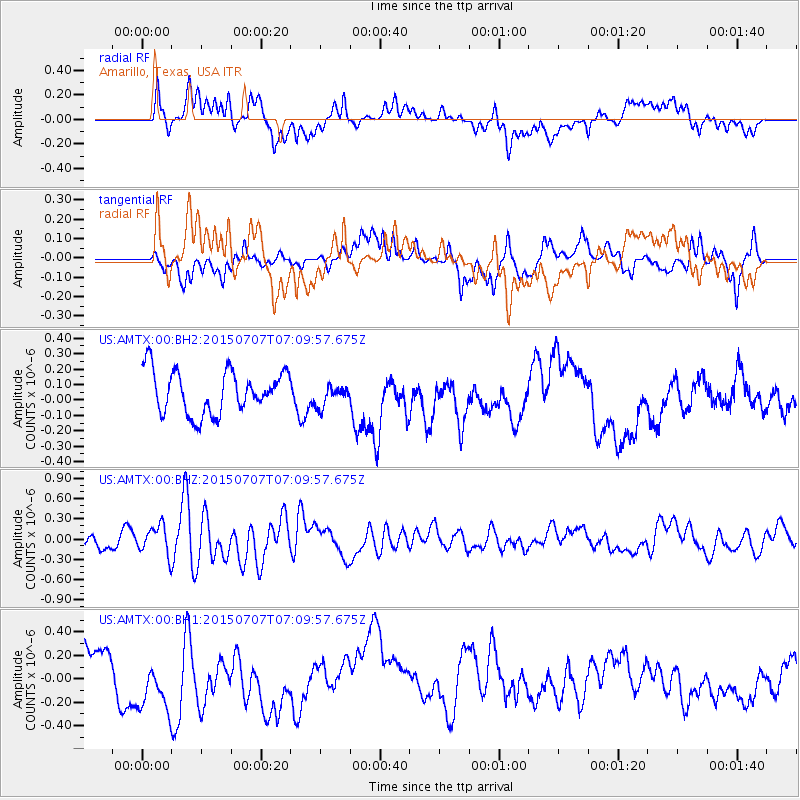
AMTX Amarillo, Texas, USA - Earthquake Result Viewer
*The percent match for this event was below the threshold and hence no stack was calculated.
| Earthquake location: |
Central East Pacific Rise |
| Earthquake latitude/longitude: |
-13.3/-111.6 |
| Earthquake time(UTC): |
2015/07/07 (188) 07:01:44 GMT |
| Earthquake Depth: |
21 km |
| Earthquake Magnitude: |
5.9 MWW, 5.9 MWC |
| Earthquake Catalog/Contributor: |
NEIC PDE/NEIC COMCAT |
|
| Network: |
US United States National Seismic Network |
| Station: |
AMTX Amarillo, Texas, USA |
| Lat/Lon: |
34.53 N/101.41 W |
| Elevation: |
1010 m |
|
| Distance: |
48.6 deg |
| Az: |
11.277 deg |
| Baz: |
193.33 deg |
| Ray Param: |
$rayparam |
*The percent match for this event was below the threshold and hence was not used in the summary stack. |
|
| Radial Match: |
61.41046 % |
| Radial Bump: |
400 |
| Transverse Match: |
63.101845 % |
| Transverse Bump: |
400 |
| SOD ConfigId: |
976571 |
| Insert Time: |
2015-07-21 07:23:56.829 +0000 |
| GWidth: |
2.5 |
| Max Bumps: |
400 |
| Tol: |
0.001 |
|
Signal To Noise
| Channel | StoN | STA | LTA |
| US:AMTX:00:BHZ:20150707T07:09:57.675Z | 2.750974 | 2.161664E-7 | 7.857813E-8 |
| US:AMTX:00:BH1:20150707T07:09:57.675Z | 1.0007594 | 2.360414E-7 | 2.3586229E-7 |
| US:AMTX:00:BH2:20150707T07:09:57.675Z | 0.7386754 | 1.0204754E-7 | 1.3814936E-7 |
| Arrivals |
| Ps | |
| PpPs | |
| PsPs/PpSs | |


