You are here: Home > Network List > TA - USArray Transportable Network (new EarthScope stations) Stations List
> Station A36M Sachs Harbour, NT, CAN > Earthquake Result Viewer
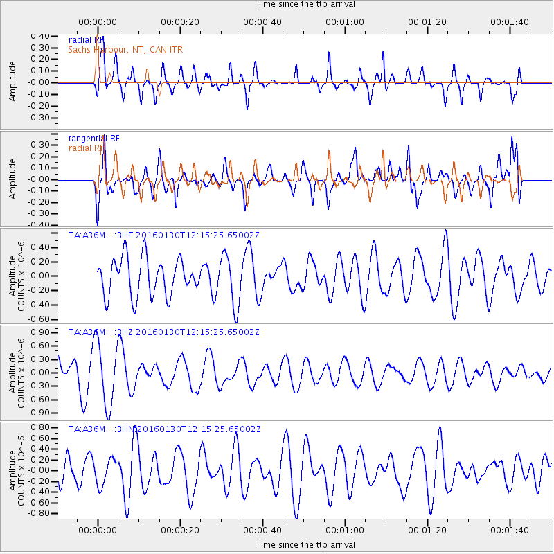
A36M Sachs Harbour, NT, CAN - Earthquake Result Viewer
*The percent match for this event was below the threshold and hence no stack was calculated.
| Earthquake location: |
Bismarck Sea |
| Earthquake latitude/longitude: |
-3.1/147.0 |
| Earthquake time(UTC): |
2016/01/30 (030) 12:02:47 GMT |
| Earthquake Depth: |
13 km |
| Earthquake Magnitude: |
5.5 mwb |
| Earthquake Catalog/Contributor: |
NEIC PDE/us |
|
| Network: |
TA USArray Transportable Network (new EarthScope stations) |
| Station: |
A36M Sachs Harbour, NT, CAN |
| Lat/Lon: |
71.99 N/125.25 W |
| Elevation: |
32 m |
|
| Distance: |
92.3 deg |
| Az: |
18.127 deg |
| Baz: |
266.912 deg |
| Ray Param: |
$rayparam |
*The percent match for this event was below the threshold and hence was not used in the summary stack. |
|
| Radial Match: |
65.62935 % |
| Radial Bump: |
360 |
| Transverse Match: |
53.358917 % |
| Transverse Bump: |
400 |
| SOD ConfigId: |
7422571 |
| Insert Time: |
2019-04-21 20:53:49.162 +0000 |
| GWidth: |
2.5 |
| Max Bumps: |
400 |
| Tol: |
0.001 |
|
Signal To Noise
| Channel | StoN | STA | LTA |
| TA:A36M: :BHZ:20160130T12:15:25.65002Z | 2.1279545 | 7.216479E-7 | 3.391275E-7 |
| TA:A36M: :BHN:20160130T12:15:25.65002Z | 0.7299504 | 2.3829804E-7 | 3.2645787E-7 |
| TA:A36M: :BHE:20160130T12:15:25.65002Z | 1.3618625 | 3.5000397E-7 | 2.5700388E-7 |
| Arrivals |
| Ps | |
| PpPs | |
| PsPs/PpSs | |


