You are here: Home > Network List > UW - Pacific Northwest Regional Seismic Network Stations List
> Station LEBA Lebam, WA, USA > Earthquake Result Viewer
LEBA Lebam, WA, USA - Earthquake Result Viewer
*The percent match for this event was below the threshold and hence no stack was calculated.
| Earthquake location: |
Bismarck Sea |
| Earthquake latitude/longitude: |
-3.1/147.0 |
| Earthquake time(UTC): |
2016/01/30 (030) 12:02:47 GMT |
| Earthquake Depth: |
13 km |
| Earthquake Magnitude: |
5.5 mwb |
| Earthquake Catalog/Contributor: |
NEIC PDE/us |
|
| Network: |
UW Pacific Northwest Regional Seismic Network |
| Station: |
LEBA Lebam, WA, USA |
| Lat/Lon: |
46.55 N/123.56 W |
| Elevation: |
73 m |
|
| Distance: |
91.9 deg |
| Az: |
43.673 deg |
| Baz: |
267.453 deg |
| Ray Param: |
$rayparam |
*The percent match for this event was below the threshold and hence was not used in the summary stack. |
|
| Radial Match: |
47.788307 % |
| Radial Bump: |
374 |
| Transverse Match: |
66.52844 % |
| Transverse Bump: |
400 |
| SOD ConfigId: |
7422571 |
| Insert Time: |
2019-04-21 20:54:15.670 +0000 |
| GWidth: |
2.5 |
| Max Bumps: |
400 |
| Tol: |
0.001 |
|
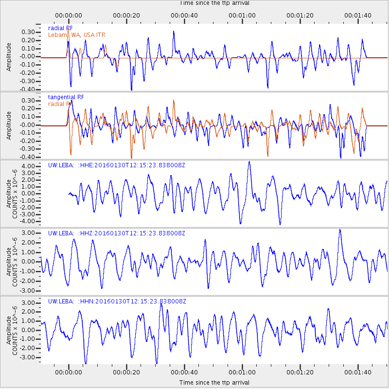
Signal To Noise
| Channel | StoN | STA | LTA |
| UW:LEBA: :HHZ:20160130T12:15:23.838008Z | 2.0243263 | 1.639092E-6 | 8.0969744E-7 |
| UW:LEBA: :HHN:20160130T12:15:23.838008Z | 0.96178097 | 1.1563263E-6 | 1.2022762E-6 |
| UW:LEBA: :HHE:20160130T12:15:23.838008Z | 1.0606587 | 1.304392E-6 | 1.2297943E-6 |
| Arrivals |
| Ps | |
| PpPs | |
| PsPs/PpSs | |


