You are here: Home > Network List > AK - Alaska Regional Network Stations List
> Station MDM Murphy Dome > Earthquake Result Viewer
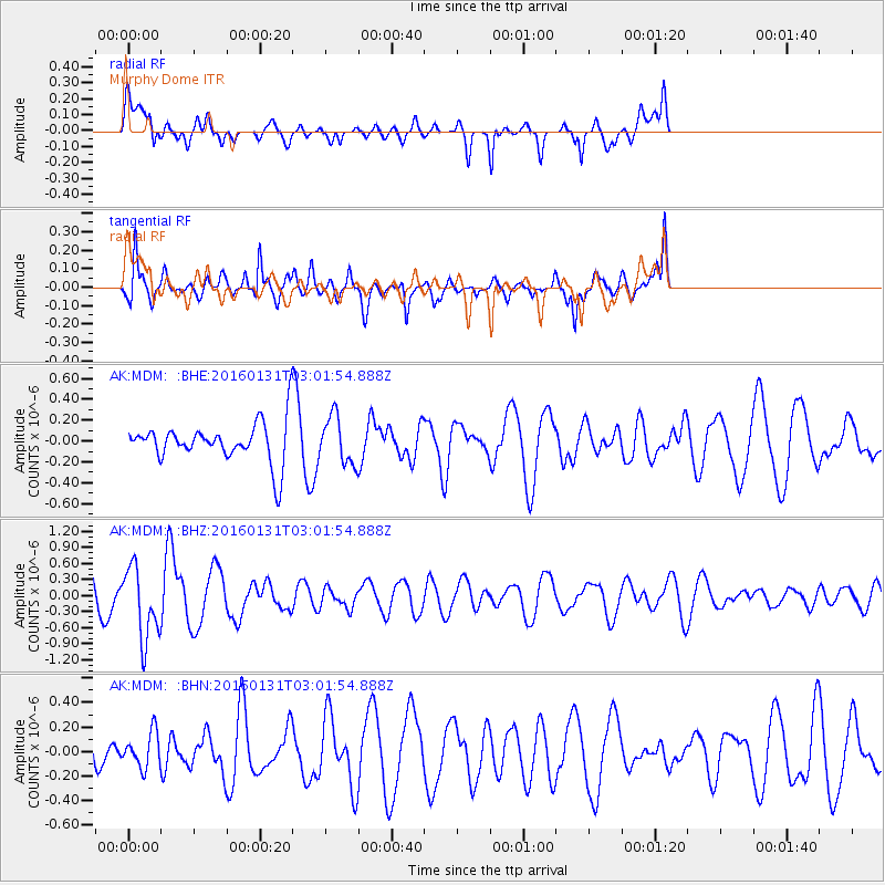
MDM Murphy Dome - Earthquake Result Viewer
*The percent match for this event was below the threshold and hence no stack was calculated.
| Earthquake location: |
Admiralty Islands Region, P.N.G. |
| Earthquake latitude/longitude: |
-2.9/147.1 |
| Earthquake time(UTC): |
2016/01/31 (031) 02:50:06 GMT |
| Earthquake Depth: |
10 km |
| Earthquake Magnitude: |
5.6 MB |
| Earthquake Catalog/Contributor: |
NEIC PDE/NEIC ALERT |
|
| Network: |
AK Alaska Regional Network |
| Station: |
MDM Murphy Dome |
| Lat/Lon: |
64.96 N/148.23 W |
| Elevation: |
634 m |
|
| Distance: |
82.1 deg |
| Az: |
22.846 deg |
| Baz: |
245.661 deg |
| Ray Param: |
$rayparam |
*The percent match for this event was below the threshold and hence was not used in the summary stack. |
|
| Radial Match: |
60.43326 % |
| Radial Bump: |
391 |
| Transverse Match: |
64.262024 % |
| Transverse Bump: |
337 |
| SOD ConfigId: |
7422571 |
| Insert Time: |
2019-04-21 20:56:04.005 +0000 |
| GWidth: |
2.5 |
| Max Bumps: |
400 |
| Tol: |
0.001 |
|
Signal To Noise
| Channel | StoN | STA | LTA |
| AK:MDM: :BHZ:20160131T03:01:54.888Z | 3.479172 | 6.7934315E-7 | 1.9526E-7 |
| AK:MDM: :BHN:20160131T03:01:54.888Z | 0.95332915 | 1.4269882E-7 | 1.4968474E-7 |
| AK:MDM: :BHE:20160131T03:01:54.888Z | 1.1216033 | 2.4157362E-7 | 2.1538243E-7 |
| Arrivals |
| Ps | |
| PpPs | |
| PsPs/PpSs | |


