You are here: Home > Network List > AZ - ANZA Regional Network Stations List
> Station LVA2 AZ.LVA2 > Earthquake Result Viewer
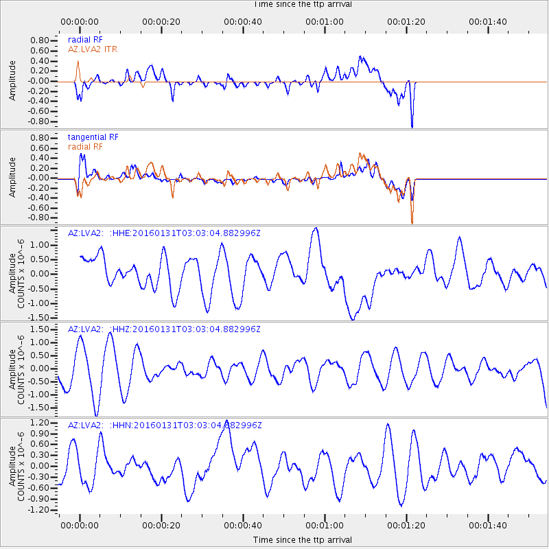
LVA2 AZ.LVA2 - Earthquake Result Viewer
*The percent match for this event was below the threshold and hence no stack was calculated.
| Earthquake location: |
Admiralty Islands Region, P.N.G. |
| Earthquake latitude/longitude: |
-2.9/147.1 |
| Earthquake time(UTC): |
2016/01/31 (031) 02:50:06 GMT |
| Earthquake Depth: |
10 km |
| Earthquake Magnitude: |
5.6 MB |
| Earthquake Catalog/Contributor: |
NEIC PDE/NEIC ALERT |
|
| Network: |
AZ ANZA Regional Network |
| Station: |
LVA2 AZ.LVA2 |
| Lat/Lon: |
33.35 N/116.56 W |
| Elevation: |
1435 m |
|
| Distance: |
96.8 deg |
| Az: |
56.919 deg |
| Baz: |
271.06 deg |
| Ray Param: |
$rayparam |
*The percent match for this event was below the threshold and hence was not used in the summary stack. |
|
| Radial Match: |
65.76205 % |
| Radial Bump: |
400 |
| Transverse Match: |
65.61112 % |
| Transverse Bump: |
400 |
| SOD ConfigId: |
7422571 |
| Insert Time: |
2019-04-21 20:56:46.959 +0000 |
| GWidth: |
2.5 |
| Max Bumps: |
400 |
| Tol: |
0.001 |
|
Signal To Noise
| Channel | StoN | STA | LTA |
| AZ:LVA2: :HHZ:20160131T03:03:04.882996Z | 2.7382236 | 1.1019637E-6 | 4.0243745E-7 |
| AZ:LVA2: :HHN:20160131T03:03:04.882996Z | 1.6143572 | 4.8027175E-7 | 2.9750032E-7 |
| AZ:LVA2: :HHE:20160131T03:03:04.882996Z | 1.660719 | 8.218657E-7 | 4.9488546E-7 |
| Arrivals |
| Ps | |
| PpPs | |
| PsPs/PpSs | |


