You are here: Home > Network List > CI - Caltech Regional Seismic Network Stations List
> Station MPP McPhearson Peak > Earthquake Result Viewer
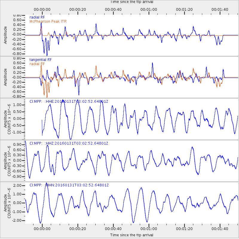
MPP McPhearson Peak - Earthquake Result Viewer
*The percent match for this event was below the threshold and hence no stack was calculated.
| Earthquake location: |
Admiralty Islands Region, P.N.G. |
| Earthquake latitude/longitude: |
-2.9/147.1 |
| Earthquake time(UTC): |
2016/01/31 (031) 02:50:06 GMT |
| Earthquake Depth: |
10 km |
| Earthquake Magnitude: |
5.6 MB |
| Earthquake Catalog/Contributor: |
NEIC PDE/NEIC ALERT |
|
| Network: |
CI Caltech Regional Seismic Network |
| Station: |
MPP McPhearson Peak |
| Lat/Lon: |
34.89 N/119.81 W |
| Elevation: |
1739 m |
|
| Distance: |
94.1 deg |
| Az: |
55.39 deg |
| Baz: |
269.39 deg |
| Ray Param: |
$rayparam |
*The percent match for this event was below the threshold and hence was not used in the summary stack. |
|
| Radial Match: |
60.278217 % |
| Radial Bump: |
400 |
| Transverse Match: |
58.077488 % |
| Transverse Bump: |
334 |
| SOD ConfigId: |
7422571 |
| Insert Time: |
2019-04-21 20:57:16.854 +0000 |
| GWidth: |
2.5 |
| Max Bumps: |
400 |
| Tol: |
0.001 |
|
Signal To Noise
| Channel | StoN | STA | LTA |
| CI:MPP: :HHZ:20160131T03:02:52.64801Z | 0.9758045 | 5.3726444E-7 | 5.5058615E-7 |
| CI:MPP: :HHN:20160131T03:02:52.64801Z | 3.3916752 | 1.5235306E-6 | 4.4919707E-7 |
| CI:MPP: :HHE:20160131T03:02:52.64801Z | 0.94830453 | 8.516798E-7 | 8.981079E-7 |
| Arrivals |
| Ps | |
| PpPs | |
| PsPs/PpSs | |


