You are here: Home > Network List > TA - USArray Transportable Network (new EarthScope stations) Stations List
> Station A21K Barrow, AK, USA > Earthquake Result Viewer
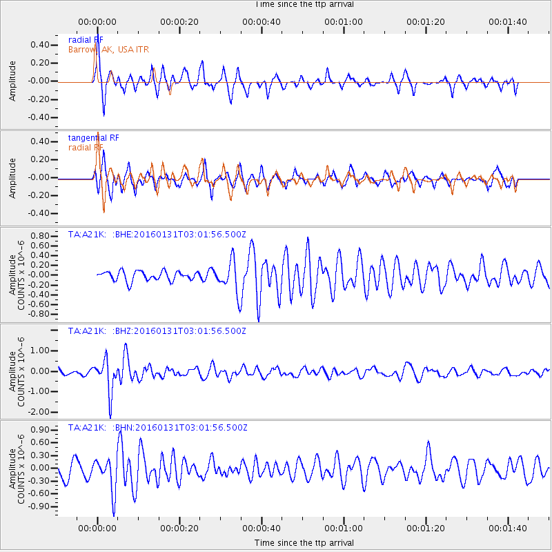
A21K Barrow, AK, USA - Earthquake Result Viewer
*The percent match for this event was below the threshold and hence no stack was calculated.
| Earthquake location: |
Admiralty Islands Region, P.N.G. |
| Earthquake latitude/longitude: |
-2.9/147.1 |
| Earthquake time(UTC): |
2016/01/31 (031) 02:50:06 GMT |
| Earthquake Depth: |
10 km |
| Earthquake Magnitude: |
5.6 MB |
| Earthquake Catalog/Contributor: |
NEIC PDE/NEIC ALERT |
|
| Network: |
TA USArray Transportable Network (new EarthScope stations) |
| Station: |
A21K Barrow, AK, USA |
| Lat/Lon: |
71.32 N/156.62 W |
| Elevation: |
577 m |
|
| Distance: |
82.4 deg |
| Az: |
15.679 deg |
| Baz: |
236.905 deg |
| Ray Param: |
$rayparam |
*The percent match for this event was below the threshold and hence was not used in the summary stack. |
|
| Radial Match: |
74.00581 % |
| Radial Bump: |
341 |
| Transverse Match: |
69.551544 % |
| Transverse Bump: |
384 |
| SOD ConfigId: |
7422571 |
| Insert Time: |
2019-04-21 20:59:37.647 +0000 |
| GWidth: |
2.5 |
| Max Bumps: |
400 |
| Tol: |
0.001 |
|
Signal To Noise
| Channel | StoN | STA | LTA |
| TA:A21K: :BHZ:20160131T03:01:56.500Z | 5.688242 | 8.026248E-7 | 1.4110243E-7 |
| TA:A21K: :BHN:20160131T03:01:56.500Z | 2.2191515 | 3.9641546E-7 | 1.786338E-7 |
| TA:A21K: :BHE:20160131T03:01:56.500Z | 3.8811324 | 3.7424647E-7 | 9.642714E-8 |
| Arrivals |
| Ps | |
| PpPs | |
| PsPs/PpSs | |


