You are here: Home > Network List > AU - Australian Seismological Centre Stations List
> Station WB2 Warramunga Array, Australia > Earthquake Result Viewer
WB2 Warramunga Array, Australia - Earthquake Result Viewer
| Earthquake location: |
Kermadec Islands Region |
| Earthquake latitude/longitude: |
-31.0/-179.9 |
| Earthquake time(UTC): |
2016/02/01 (032) 19:00:44 GMT |
| Earthquake Depth: |
370 km |
| Earthquake Magnitude: |
5.8 MB |
| Earthquake Catalog/Contributor: |
NEIC PDE/NEIC COMCAT |
|
| Network: |
AU Australian Seismological Centre |
| Station: |
WB2 Warramunga Array, Australia |
| Lat/Lon: |
19.94 S/134.35 E |
| Elevation: |
388 m |
|
| Distance: |
42.5 deg |
| Az: |
273.854 deg |
| Baz: |
114.387 deg |
| Ray Param: |
0.07155577 |
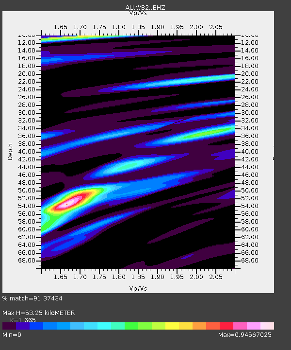
| Estimated Moho Depth: |
53.25 km |
| Estimated Crust Vp/Vs: |
1.66 |
| Assumed Crust Vp: |
6.642 km/s |
| Estimated Crust Vs: |
3.989 km/s |
| Estimated Crust Poisson's Ratio: |
0.22 |
|
| Radial Match: |
91.37434 % |
| Radial Bump: |
361 |
| Transverse Match: |
60.759693 % |
| Transverse Bump: |
400 |
| SOD ConfigId: |
7422571 |
| Insert Time: |
2019-04-21 21:04:48.648 +0000 |
| GWidth: |
2.5 |
| Max Bumps: |
400 |
| Tol: |
0.001 |
|

Signal To Noise
| Channel | StoN | STA | LTA |
| AU:WB2: :BHZ:20160201T19:07:33.850005Z | 14.791469 | 3.0926712E-6 | 2.0908479E-7 |
| AU:WB2: :BHN:20160201T19:07:33.850005Z | 5.6098776 | 7.5153866E-7 | 1.3396703E-7 |
| AU:WB2: :BHE:20160201T19:07:33.850005Z | 12.084034 | 1.7663837E-6 | 1.46175E-7 |
| Arrivals |
| Ps | 5.7 SECOND |
| PpPs | 20 SECOND |
| PsPs/PpSs | 26 SECOND |


