You are here: Home > Network List > CI - Caltech Regional Seismic Network Stations List
> Station MPM Manuel Prospect Mine, California, USA > Earthquake Result Viewer
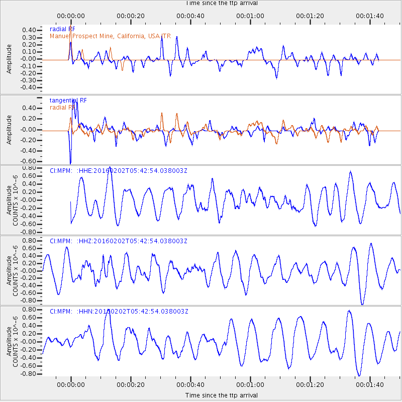
MPM Manuel Prospect Mine, California, USA - Earthquake Result Viewer
*The percent match for this event was below the threshold and hence no stack was calculated.
| Earthquake location: |
Near East Coast Of Honshu, Japan |
| Earthquake latitude/longitude: |
39.7/143.0 |
| Earthquake time(UTC): |
2016/02/02 (033) 05:31:48 GMT |
| Earthquake Depth: |
18 km |
| Earthquake Magnitude: |
5.6 MB |
| Earthquake Catalog/Contributor: |
NEIC PDE/NEIC COMCAT |
|
| Network: |
CI Caltech Regional Seismic Network |
| Station: |
MPM Manuel Prospect Mine, California, USA |
| Lat/Lon: |
36.06 N/117.49 W |
| Elevation: |
185 m |
|
| Distance: |
74.4 deg |
| Az: |
56.054 deg |
| Baz: |
307.793 deg |
| Ray Param: |
$rayparam |
*The percent match for this event was below the threshold and hence was not used in the summary stack. |
|
| Radial Match: |
38.478436 % |
| Radial Bump: |
400 |
| Transverse Match: |
62.032715 % |
| Transverse Bump: |
400 |
| SOD ConfigId: |
7422571 |
| Insert Time: |
2019-04-21 21:11:44.461 +0000 |
| GWidth: |
2.5 |
| Max Bumps: |
400 |
| Tol: |
0.001 |
|
Signal To Noise
| Channel | StoN | STA | LTA |
| CI:MPM: :HHZ:20160202T05:42:54.038003Z | 0.8733055 | 2.345935E-7 | 2.6862708E-7 |
| CI:MPM: :HHN:20160202T05:42:54.038003Z | 1.4648776 | 1.8852445E-7 | 1.2869639E-7 |
| CI:MPM: :HHE:20160202T05:42:54.038003Z | 0.8281657 | 2.9714454E-7 | 3.5879842E-7 |
| Arrivals |
| Ps | |
| PpPs | |
| PsPs/PpSs | |


