You are here: Home > Network List > CI - Caltech Regional Seismic Network Stations List
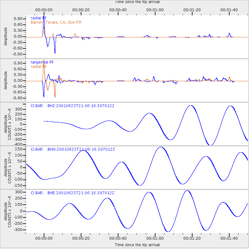
> Station BAR Barrett, Tecate, CA, USA > Earthquake Result Viewer
BAR Barrett, Tecate, CA, USA - Earthquake Result Viewer
| Earthquake location: |
Near Coast Of Peru |
| Earthquake latitude/longitude: |
-17.4/-72.2 |
| Earthquake time(UTC): |
2001/06/23 (174) 20:56:07 GMT |
| Earthquake Depth: |
33 km |
| Earthquake Magnitude: |
5.8 MB |
| Earthquake Catalog/Contributor: |
WHDF/NEIC |
|
| Network: |
CI Caltech Regional Seismic Network |
| Station: |
BAR Barrett, Tecate, CA, USA |
| Lat/Lon: |
32.68 N/116.67 W |
| Elevation: |
521 m |
|
| Distance: |
65.5 deg |
| Az: |
319.487 deg |
| Baz: |
132.652 deg |
| Ray Param: |
0.058172416 |
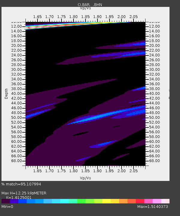
| Estimated Moho Depth: |
12.25 km |
| Estimated Crust Vp/Vs: |
1.61 |
| Assumed Crust Vp: |
6.264 km/s |
| Estimated Crust Vs: |
3.884 km/s |
| Estimated Crust Poisson's Ratio: |
0.19 |
|
| Radial Match: |
95.107994 % |
| Radial Bump: |
396 |
| Transverse Match: |
79.055244 % |
| Transverse Bump: |
400 |
| SOD ConfigId: |
3753 |
| Insert Time: |
2010-02-26 00:06:20.805 +0000 |
| GWidth: |
2.5 |
| Max Bumps: |
400 |
| Tol: |
0.001 |
|
Signal To Noise
| Channel | StoN | STA | LTA |
| CI:BAR: :BHN:20010623T21:06:16.397012Z | 2.4240491 | 1.1356163E-4 | 4.684791E-5 |
| CI:BAR: :BHE:20010623T21:06:16.397012Z | 1.687755 | 1.33677E-4 | 7.920402E-5 |
| CI:BAR: :BHZ:20010623T21:06:16.397012Z | 0.8917647 | 4.967379E-5 | 5.57028E-5 |
| Arrivals |
| Ps | 1.3 SECOND |
| PpPs | 4.9 SECOND |
| PsPs/PpSs | 6.1 SECOND |


