You are here: Home > Network List > TA - USArray Transportable Network (new EarthScope stations) Stations List
> Station J26L Joseph Creek, AK, USA > Earthquake Result Viewer
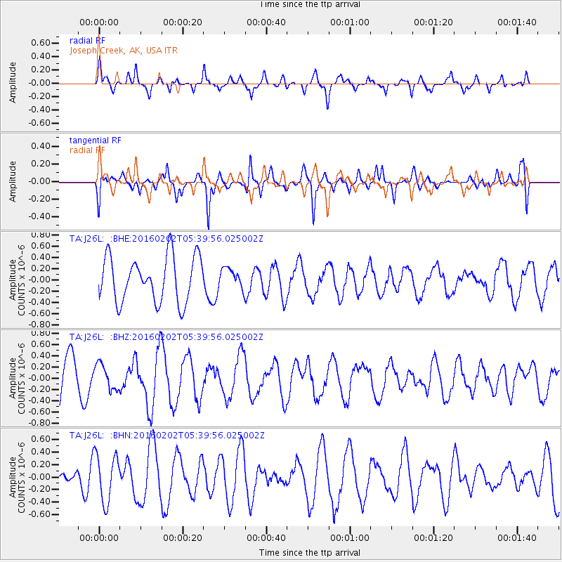
J26L Joseph Creek, AK, USA - Earthquake Result Viewer
*The percent match for this event was below the threshold and hence no stack was calculated.
| Earthquake location: |
Near East Coast Of Honshu, Japan |
| Earthquake latitude/longitude: |
39.7/143.0 |
| Earthquake time(UTC): |
2016/02/02 (033) 05:31:48 GMT |
| Earthquake Depth: |
18 km |
| Earthquake Magnitude: |
5.6 MB |
| Earthquake Catalog/Contributor: |
NEIC PDE/NEIC COMCAT |
|
| Network: |
TA USArray Transportable Network (new EarthScope stations) |
| Station: |
J26L Joseph Creek, AK, USA |
| Lat/Lon: |
64.50 N/143.56 W |
| Elevation: |
1144 m |
|
| Distance: |
48.1 deg |
| Az: |
33.9 deg |
| Baz: |
275.969 deg |
| Ray Param: |
$rayparam |
*The percent match for this event was below the threshold and hence was not used in the summary stack. |
|
| Radial Match: |
79.302055 % |
| Radial Bump: |
391 |
| Transverse Match: |
66.27395 % |
| Transverse Bump: |
400 |
| SOD ConfigId: |
7422571 |
| Insert Time: |
2019-04-21 21:16:18.970 +0000 |
| GWidth: |
2.5 |
| Max Bumps: |
400 |
| Tol: |
0.001 |
|
Signal To Noise
| Channel | StoN | STA | LTA |
| TA:J26L: :BHZ:20160202T05:39:56.025002Z | 0.5811911 | 2.2652912E-7 | 3.89767E-7 |
| TA:J26L: :BHN:20160202T05:39:56.025002Z | 2.0858657 | 3.7671367E-7 | 1.8060302E-7 |
| TA:J26L: :BHE:20160202T05:39:56.025002Z | 0.4410509 | 1.7868967E-7 | 4.0514527E-7 |
| Arrivals |
| Ps | |
| PpPs | |
| PsPs/PpSs | |


