You are here: Home > Network List > TA - USArray Transportable Network (new EarthScope stations) Stations List
> Station R11A Troy Canyon, Currant, NV, USA > Earthquake Result Viewer
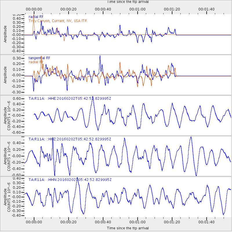
R11A Troy Canyon, Currant, NV, USA - Earthquake Result Viewer
*The percent match for this event was below the threshold and hence no stack was calculated.
| Earthquake location: |
Near East Coast Of Honshu, Japan |
| Earthquake latitude/longitude: |
39.7/143.0 |
| Earthquake time(UTC): |
2016/02/02 (033) 05:31:48 GMT |
| Earthquake Depth: |
18 km |
| Earthquake Magnitude: |
5.6 MB |
| Earthquake Catalog/Contributor: |
NEIC PDE/NEIC COMCAT |
|
| Network: |
TA USArray Transportable Network (new EarthScope stations) |
| Station: |
R11A Troy Canyon, Currant, NV, USA |
| Lat/Lon: |
38.35 N/115.59 W |
| Elevation: |
1756 m |
|
| Distance: |
74.2 deg |
| Az: |
53.21 deg |
| Baz: |
308.17 deg |
| Ray Param: |
$rayparam |
*The percent match for this event was below the threshold and hence was not used in the summary stack. |
|
| Radial Match: |
78.20214 % |
| Radial Bump: |
400 |
| Transverse Match: |
63.17495 % |
| Transverse Bump: |
400 |
| SOD ConfigId: |
7422571 |
| Insert Time: |
2019-04-21 21:16:30.648 +0000 |
| GWidth: |
2.5 |
| Max Bumps: |
400 |
| Tol: |
0.001 |
|
Signal To Noise
| Channel | StoN | STA | LTA |
| TA:R11A: :HHZ:20160202T05:42:52.829995Z | 0.70409894 | 1.7811993E-7 | 2.5297572E-7 |
| TA:R11A: :HHN:20160202T05:42:52.829995Z | 0.736217 | 1.1993221E-7 | 1.6290333E-7 |
| TA:R11A: :HHE:20160202T05:42:52.829995Z | 3.3385165 | 3.8135144E-7 | 1.1422781E-7 |
| Arrivals |
| Ps | |
| PpPs | |
| PsPs/PpSs | |


