You are here: Home > Network List > CI - Caltech Regional Seismic Network Stations List
> Station BAR Barrett, Tecate, CA, USA > Earthquake Result Viewer
BAR Barrett, Tecate, CA, USA - Earthquake Result Viewer
| Earthquake location: |
Near Coast Of Peru |
| Earthquake latitude/longitude: |
-16.3/-73.6 |
| Earthquake time(UTC): |
2001/06/23 (174) 20:33:14 GMT |
| Earthquake Depth: |
33 km |
| Earthquake Magnitude: |
6.7 MB, 8.2 MS, 8.4 MW, 7.8 ME |
| Earthquake Catalog/Contributor: |
WHDF/NEIC |
|
| Network: |
CI Caltech Regional Seismic Network |
| Station: |
BAR Barrett, Tecate, CA, USA |
| Lat/Lon: |
32.68 N/116.67 W |
| Elevation: |
521 m |
|
| Distance: |
63.7 deg |
| Az: |
320.078 deg |
| Baz: |
133.039 deg |
| Ray Param: |
0.059329465 |
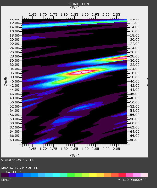
| Estimated Moho Depth: |
35.5 km |
| Estimated Crust Vp/Vs: |
1.88 |
| Assumed Crust Vp: |
6.264 km/s |
| Estimated Crust Vs: |
3.327 km/s |
| Estimated Crust Poisson's Ratio: |
0.30 |
|
| Radial Match: |
96.37614 % |
| Radial Bump: |
287 |
| Transverse Match: |
86.74809 % |
| Transverse Bump: |
400 |
| SOD ConfigId: |
3753 |
| Insert Time: |
2010-02-26 00:06:28.319 +0000 |
| GWidth: |
2.5 |
| Max Bumps: |
400 |
| Tol: |
0.001 |
|
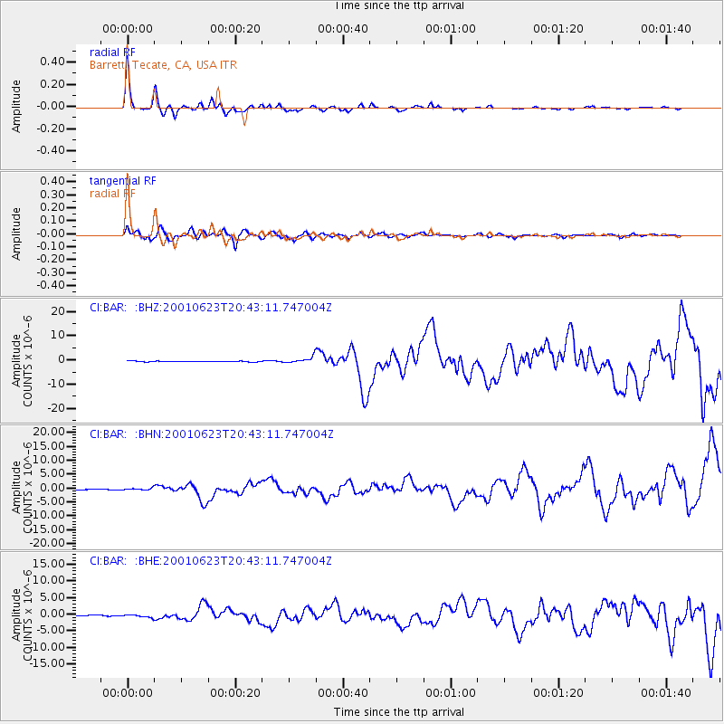
Signal To Noise
| Channel | StoN | STA | LTA |
| CI:BAR: :BHN:20010623T20:43:11.747004Z | 2.7799973 | 4.1073184E-7 | 1.4774541E-7 |
| CI:BAR: :BHE:20010623T20:43:11.747004Z | 4.0945277 | 4.5757025E-7 | 1.1175165E-7 |
| CI:BAR: :BHZ:20010623T20:43:11.747004Z | 8.054492 | 1.3006844E-6 | 1.6148559E-7 |
| Arrivals |
| Ps | 5.2 SECOND |
| PpPs | 16 SECOND |
| PsPs/PpSs | 21 SECOND |


