You are here: Home > Network List > US - United States National Seismic Network Stations List
> Station ELK Elko, Nevada, USA > Earthquake Result Viewer
ELK Elko, Nevada, USA - Earthquake Result Viewer
*The percent match for this event was below the threshold and hence no stack was calculated.
| Earthquake location: |
South Of Fiji Islands |
| Earthquake latitude/longitude: |
-23.1/-177.0 |
| Earthquake time(UTC): |
2015/07/07 (188) 20:03:13 GMT |
| Earthquake Depth: |
120 km |
| Earthquake Magnitude: |
5.8 MO |
| Earthquake Catalog/Contributor: |
NEIC PDE/NEIC ALERT |
|
| Network: |
US United States National Seismic Network |
| Station: |
ELK Elko, Nevada, USA |
| Lat/Lon: |
40.74 N/115.24 W |
| Elevation: |
2210 m |
|
| Distance: |
85.6 deg |
| Az: |
42.187 deg |
| Baz: |
234.479 deg |
| Ray Param: |
$rayparam |
*The percent match for this event was below the threshold and hence was not used in the summary stack. |
|
| Radial Match: |
48.267677 % |
| Radial Bump: |
400 |
| Transverse Match: |
53.727745 % |
| Transverse Bump: |
400 |
| SOD ConfigId: |
976571 |
| Insert Time: |
2015-07-21 20:39:46.858 +0000 |
| GWidth: |
2.5 |
| Max Bumps: |
400 |
| Tol: |
0.001 |
|
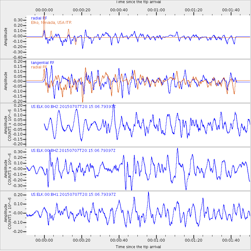
Signal To Noise
| Channel | StoN | STA | LTA |
| US:ELK:00:BHZ:20150707T20:15:06.79397Z | 2.0170803 | 1.4725688E-7 | 7.300497E-8 |
| US:ELK:00:BH1:20150707T20:15:06.79397Z | 1.1180581 | 5.4186202E-8 | 4.846457E-8 |
| US:ELK:00:BH2:20150707T20:15:06.79397Z | 0.4947954 | 3.7966775E-8 | 7.673227E-8 |
| Arrivals |
| Ps | |
| PpPs | |
| PsPs/PpSs | |


