You are here: Home > Network List > UW - Pacific Northwest Regional Seismic Network Stations List
> Station YACT Amboy, WA, USA > Earthquake Result Viewer
YACT Amboy, WA, USA - Earthquake Result Viewer
*The percent match for this event was below the threshold and hence no stack was calculated.
| Earthquake location: |
Northeast Of Taiwan |
| Earthquake latitude/longitude: |
25.6/123.5 |
| Earthquake time(UTC): |
2016/02/02 (033) 14:19:22 GMT |
| Earthquake Depth: |
188 km |
| Earthquake Magnitude: |
5.8 MB, 5.7 MWB |
| Earthquake Catalog/Contributor: |
NEIC PDE/NEIC COMCAT |
|
| Network: |
UW Pacific Northwest Regional Seismic Network |
| Station: |
YACT Amboy, WA, USA |
| Lat/Lon: |
45.93 N/122.42 W |
| Elevation: |
211 m |
|
| Distance: |
87.1 deg |
| Az: |
39.629 deg |
| Baz: |
304.382 deg |
| Ray Param: |
$rayparam |
*The percent match for this event was below the threshold and hence was not used in the summary stack. |
|
| Radial Match: |
65.281334 % |
| Radial Bump: |
400 |
| Transverse Match: |
49.54983 % |
| Transverse Bump: |
400 |
| SOD ConfigId: |
7422571 |
| Insert Time: |
2019-04-21 21:24:51.248 +0000 |
| GWidth: |
2.5 |
| Max Bumps: |
400 |
| Tol: |
0.001 |
|
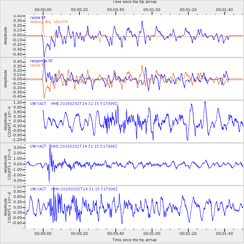
Signal To Noise
| Channel | StoN | STA | LTA |
| UW:YACT: :HHZ:20160202T14:31:15.517996Z | 4.2737646 | 1.1672574E-6 | 2.731216E-7 |
| UW:YACT: :HHN:20160202T14:31:15.517996Z | 0.7626275 | 2.2331818E-7 | 2.9282734E-7 |
| UW:YACT: :HHE:20160202T14:31:15.517996Z | 1.2026464 | 3.7601112E-7 | 3.1265313E-7 |
| Arrivals |
| Ps | |
| PpPs | |
| PsPs/PpSs | |


