You are here: Home > Network List > CN - Canadian National Seismograph Network Stations List
> Station INK INUVIK, NT > Earthquake Result Viewer
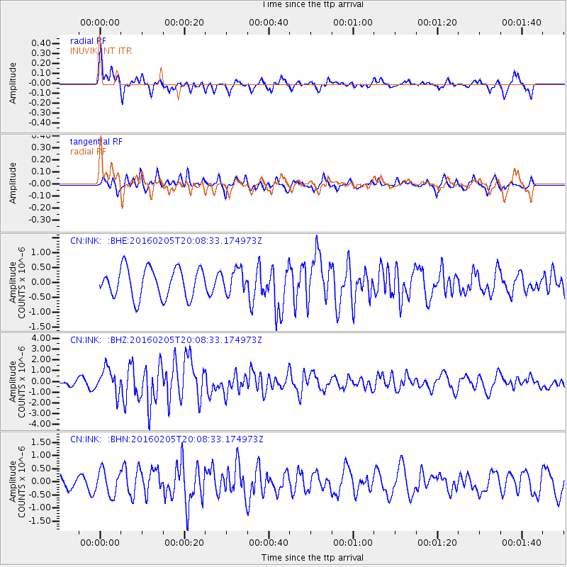
INK INUVIK, NT - Earthquake Result Viewer
*The percent match for this event was below the threshold and hence no stack was calculated.
| Earthquake location: |
Taiwan |
| Earthquake latitude/longitude: |
22.9/120.6 |
| Earthquake time(UTC): |
2016/02/05 (036) 19:57:27 GMT |
| Earthquake Depth: |
23 km |
| Earthquake Magnitude: |
6.4 MWW, 6.3 MWB, 6.4 MWC, 6.7 MI |
| Earthquake Catalog/Contributor: |
NEIC PDE/NEIC COMCAT |
|
| Network: |
CN Canadian National Seismograph Network |
| Station: |
INK INUVIK, NT |
| Lat/Lon: |
68.31 N/133.53 W |
| Elevation: |
44 m |
|
| Distance: |
74.6 deg |
| Az: |
21.775 deg |
| Baz: |
293.104 deg |
| Ray Param: |
$rayparam |
*The percent match for this event was below the threshold and hence was not used in the summary stack. |
|
| Radial Match: |
69.79888 % |
| Radial Bump: |
395 |
| Transverse Match: |
63.502434 % |
| Transverse Bump: |
400 |
| SOD ConfigId: |
7422571 |
| Insert Time: |
2019-04-21 21:28:27.985 +0000 |
| GWidth: |
2.5 |
| Max Bumps: |
400 |
| Tol: |
0.001 |
|
Signal To Noise
| Channel | StoN | STA | LTA |
| CN:INK: :BHZ:20160205T20:08:33.174973Z | 3.6766443 | 1.1715216E-6 | 3.186388E-7 |
| CN:INK: :BHN:20160205T20:08:33.174973Z | 1.1379641 | 4.6871398E-7 | 4.1188818E-7 |
| CN:INK: :BHE:20160205T20:08:33.174973Z | 0.7920625 | 3.899037E-7 | 4.922638E-7 |
| Arrivals |
| Ps | |
| PpPs | |
| PsPs/PpSs | |


