You are here: Home > Network List > TA - USArray Transportable Network (new EarthScope stations) Stations List
> Station A21K Barrow, AK, USA > Earthquake Result Viewer
A21K Barrow, AK, USA - Earthquake Result Viewer
| Earthquake location: |
Taiwan |
| Earthquake latitude/longitude: |
22.9/120.6 |
| Earthquake time(UTC): |
2016/02/05 (036) 19:57:27 GMT |
| Earthquake Depth: |
23 km |
| Earthquake Magnitude: |
6.4 MWW, 6.3 MWB, 6.4 MWC, 6.7 MI |
| Earthquake Catalog/Contributor: |
NEIC PDE/NEIC COMCAT |
|
| Network: |
TA USArray Transportable Network (new EarthScope stations) |
| Station: |
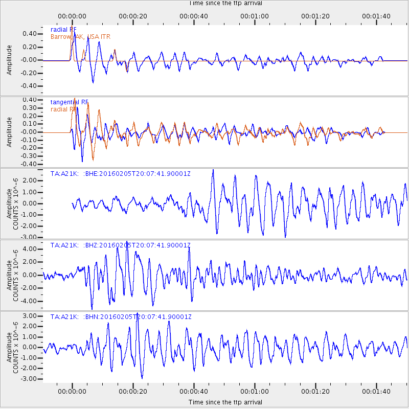
A21K Barrow, AK, USA |
| Lat/Lon: |
71.32 N/156.62 W |
| Elevation: |
577 m |
|
| Distance: |
66.2 deg |
| Az: |
20.453 deg |
| Baz: |
270.96 deg |
| Ray Param: |
0.057768367 |
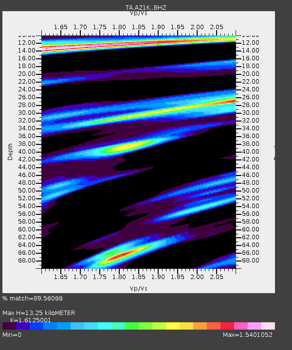
| Estimated Moho Depth: |
13.25 km |
| Estimated Crust Vp/Vs: |
1.61 |
| Assumed Crust Vp: |
6.048 km/s |
| Estimated Crust Vs: |
3.751 km/s |
| Estimated Crust Poisson's Ratio: |
0.19 |
|
| Radial Match: |
89.56066 % |
| Radial Bump: |
400 |
| Transverse Match: |
89.69465 % |
| Transverse Bump: |
400 |
| SOD ConfigId: |
7422571 |
| Insert Time: |
2019-04-21 21:30:39.668 +0000 |
| GWidth: |
2.5 |
| Max Bumps: |
400 |
| Tol: |
0.001 |
|
Signal To Noise
| Channel | StoN | STA | LTA |
| TA:A21K: :BHZ:20160205T20:07:41.90001Z | 2.9205651 | 8.3193754E-7 | 2.84855E-7 |
| TA:A21K: :BHN:20160205T20:07:41.90001Z | 1.2695507 | 3.44452E-7 | 2.7131802E-7 |
| TA:A21K: :BHE:20160205T20:07:41.90001Z | 1.1921037 | 4.1859454E-7 | 3.5113933E-7 |
| Arrivals |
| Ps | 1.4 SECOND |
| PpPs | 5.5 SECOND |
| PsPs/PpSs | 6.9 SECOND |


