You are here: Home > Network List > TA - USArray Transportable Network (new EarthScope stations) Stations List
> Station H21K Melozitna River, AK, USA > Earthquake Result Viewer
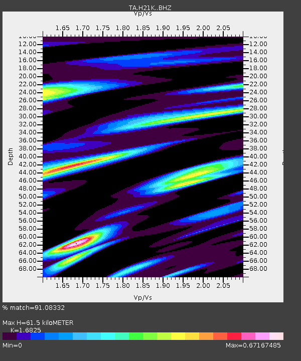
H21K Melozitna River, AK, USA - Earthquake Result Viewer
| Earthquake location: |
Taiwan |
| Earthquake latitude/longitude: |
22.9/120.6 |
| Earthquake time(UTC): |
2016/02/05 (036) 19:57:27 GMT |
| Earthquake Depth: |
23 km |
| Earthquake Magnitude: |
6.4 MWW, 6.3 MWB, 6.4 MWC, 6.7 MI |
| Earthquake Catalog/Contributor: |
NEIC PDE/NEIC COMCAT |
|
| Network: |
TA USArray Transportable Network (new EarthScope stations) |
| Station: |
H21K Melozitna River, AK, USA |
| Lat/Lon: |
65.66 N/152.80 W |
| Elevation: |
520 m |
|
| Distance: |
68.0 deg |
| Az: |
26.513 deg |
| Baz: |
276.872 deg |
| Ray Param: |
0.056591295 |
| Estimated Moho Depth: |
61.5 km |
| Estimated Crust Vp/Vs: |
1.68 |
| Assumed Crust Vp: |
6.566 km/s |
| Estimated Crust Vs: |
3.903 km/s |
| Estimated Crust Poisson's Ratio: |
0.23 |
|
| Radial Match: |
91.08332 % |
| Radial Bump: |
398 |
| Transverse Match: |
69.598015 % |
| Transverse Bump: |
400 |
| SOD ConfigId: |
7422571 |
| Insert Time: |
2019-04-21 21:30:41.926 +0000 |
| GWidth: |
2.5 |
| Max Bumps: |
400 |
| Tol: |
0.001 |
|

Signal To Noise
| Channel | StoN | STA | LTA |
| TA:H21K: :BHZ:20160205T20:07:53.249985Z | 2.6526628 | 7.0051453E-7 | 2.6407974E-7 |
| TA:H21K: :BHN:20160205T20:07:53.249985Z | 0.8754269 | 3.118587E-7 | 3.5623617E-7 |
| TA:H21K: :BHE:20160205T20:07:53.249985Z | 1.9985869 | 5.456704E-7 | 2.730281E-7 |
| Arrivals |
| Ps | 6.7 SECOND |
| PpPs | 24 SECOND |
| PsPs/PpSs | 31 SECOND |


