You are here: Home > Network List > TA - USArray Transportable Network (new EarthScope stations) Stations List
> Station H24K Noodor Dome, AK, USA > Earthquake Result Viewer
H24K Noodor Dome, AK, USA - Earthquake Result Viewer
| Earthquake location: |
Taiwan |
| Earthquake latitude/longitude: |
22.9/120.6 |
| Earthquake time(UTC): |
2016/02/05 (036) 19:57:27 GMT |
| Earthquake Depth: |
23 km |
| Earthquake Magnitude: |
6.4 MWW, 6.3 MWB, 6.4 MWC, 6.7 MI |
| Earthquake Catalog/Contributor: |
NEIC PDE/NEIC COMCAT |
|
| Network: |
TA USArray Transportable Network (new EarthScope stations) |
| Station: |
H24K Noodor Dome, AK, USA |
| Lat/Lon: |
65.84 N/147.88 W |
| Elevation: |
814 m |
|
| Distance: |
69.9 deg |
| Az: |
25.98 deg |
| Baz: |
281.168 deg |
| Ray Param: |
0.05528789 |
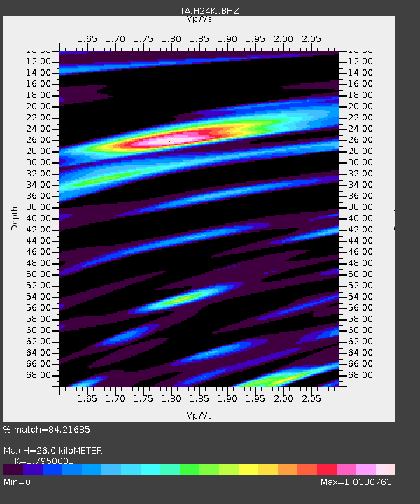
| Estimated Moho Depth: |
26.0 km |
| Estimated Crust Vp/Vs: |
1.80 |
| Assumed Crust Vp: |
6.566 km/s |
| Estimated Crust Vs: |
3.658 km/s |
| Estimated Crust Poisson's Ratio: |
0.27 |
|
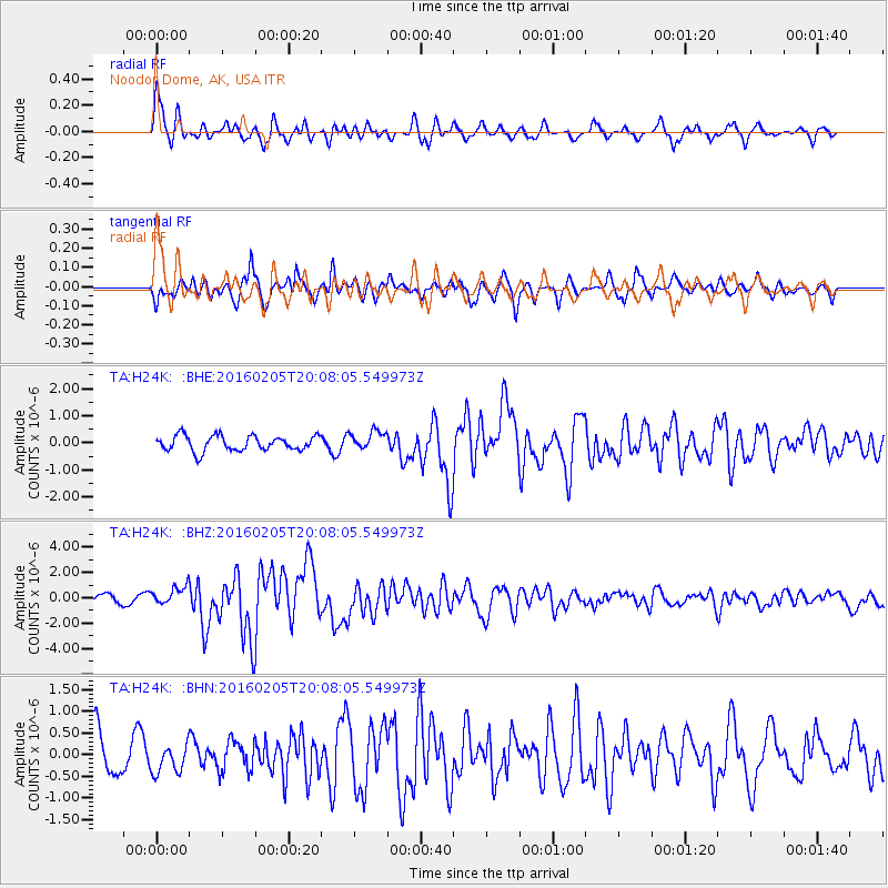
| Radial Match: |
84.21685 % |
| Radial Bump: |
400 |
| Transverse Match: |
76.62528 % |
| Transverse Bump: |
400 |
| SOD ConfigId: |
7422571 |
| Insert Time: |
2019-04-21 21:30:42.420 +0000 |
| GWidth: |
2.5 |
| Max Bumps: |
400 |
| Tol: |
0.001 |
|
Signal To Noise
| Channel | StoN | STA | LTA |
| TA:H24K: :BHZ:20160205T20:08:05.549973Z | 2.019017 | 7.3852414E-7 | 3.6578402E-7 |
| TA:H24K: :BHN:20160205T20:08:05.549973Z | 0.7432294 | 3.2563582E-7 | 4.3813637E-7 |
| TA:H24K: :BHE:20160205T20:08:05.549973Z | 1.2464632 | 3.4802827E-7 | 2.7921263E-7 |
| Arrivals |
| Ps | 3.3 SECOND |
| PpPs | 11 SECOND |
| PsPs/PpSs | 14 SECOND |


