You are here: Home > Network List > TJ - Tajikistan National Seismic Network Stations List
> Station GARM Garm, Tajikistan > Earthquake Result Viewer
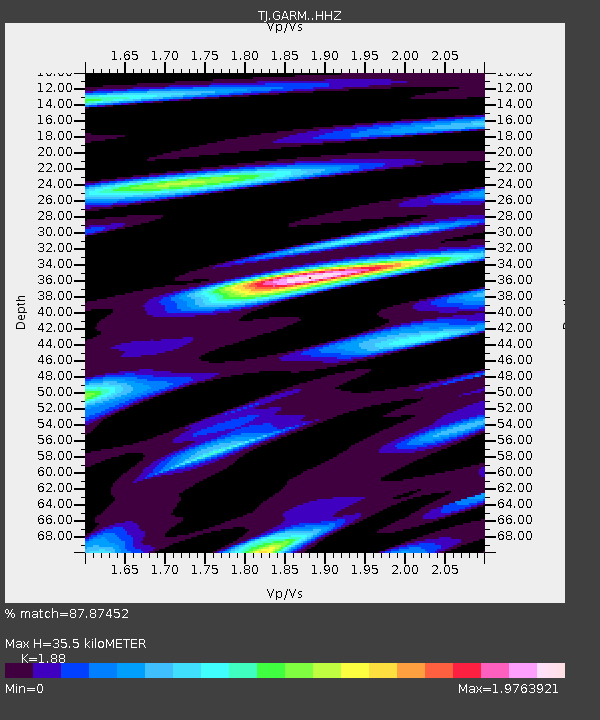
GARM Garm, Tajikistan - Earthquake Result Viewer
| Earthquake location: |
Taiwan |
| Earthquake latitude/longitude: |
22.9/120.6 |
| Earthquake time(UTC): |
2016/02/05 (036) 19:57:27 GMT |
| Earthquake Depth: |
23 km |
| Earthquake Magnitude: |
6.4 MWW, 6.3 MWB, 6.4 MWC, 6.7 MI |
| Earthquake Catalog/Contributor: |
NEIC PDE/NEIC COMCAT |
|
| Network: |
TJ Tajikistan National Seismic Network |
| Station: |
GARM Garm, Tajikistan |
| Lat/Lon: |
39.00 N/70.32 E |
| Elevation: |
1305 m |
|
| Distance: |
45.4 deg |
| Az: |
302.703 deg |
| Baz: |
95.421 deg |
| Ray Param: |
0.071256116 |
| Estimated Moho Depth: |
35.5 km |
| Estimated Crust Vp/Vs: |
1.88 |
| Assumed Crust Vp: |
6.306 km/s |
| Estimated Crust Vs: |
3.354 km/s |
| Estimated Crust Poisson's Ratio: |
0.30 |
|
| Radial Match: |
87.87452 % |
| Radial Bump: |
396 |
| Transverse Match: |
70.82607 % |
| Transverse Bump: |
400 |
| SOD ConfigId: |
7422571 |
| Insert Time: |
2019-04-21 21:30:59.609 +0000 |
| GWidth: |
2.5 |
| Max Bumps: |
400 |
| Tol: |
0.001 |
|

Signal To Noise
| Channel | StoN | STA | LTA |
| TJ:GARM: :HHZ:20160205T20:05:13.439988Z | 15.482309 | 2.3583523E-6 | 1.5232561E-7 |
| TJ:GARM: :HHN:20160205T20:05:13.439988Z | 1.9134325 | 2.733171E-7 | 1.4284127E-7 |
| TJ:GARM: :HHE:20160205T20:05:13.439988Z | 10.408175 | 1.2273435E-6 | 1.1792111E-7 |
| Arrivals |
| Ps | 5.2 SECOND |
| PpPs | 15 SECOND |
| PsPs/PpSs | 21 SECOND |


