You are here: Home > Network List > TJ - Tajikistan National Seismic Network Stations List
> Station CHGR Chuyangaron, Tajikistan > Earthquake Result Viewer
CHGR Chuyangaron, Tajikistan - Earthquake Result Viewer
| Earthquake location: |
Taiwan |
| Earthquake latitude/longitude: |
22.9/120.6 |
| Earthquake time(UTC): |
2016/02/05 (036) 19:57:27 GMT |
| Earthquake Depth: |
23 km |
| Earthquake Magnitude: |
6.4 MWW, 6.3 MWB, 6.4 MWC, 6.7 MI |
| Earthquake Catalog/Contributor: |
NEIC PDE/NEIC COMCAT |
|
| Network: |
TJ Tajikistan National Seismic Network |
| Station: |
CHGR Chuyangaron, Tajikistan |
| Lat/Lon: |
38.66 N/69.16 E |
| Elevation: |
1049 m |
|
| Distance: |
46.3 deg |
| Az: |
302.121 deg |
| Baz: |
94.292 deg |
| Ray Param: |
0.07070316 |
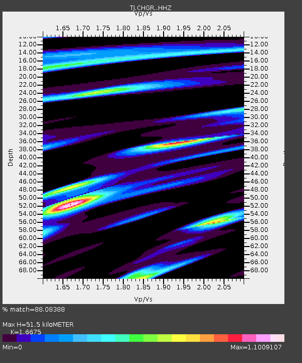
| Estimated Moho Depth: |
51.5 km |
| Estimated Crust Vp/Vs: |
1.67 |
| Assumed Crust Vp: |
6.483 km/s |
| Estimated Crust Vs: |
3.888 km/s |
| Estimated Crust Poisson's Ratio: |
0.22 |
|
| Radial Match: |
88.08388 % |
| Radial Bump: |
400 |
| Transverse Match: |
77.62222 % |
| Transverse Bump: |
400 |
| SOD ConfigId: |
7422571 |
| Insert Time: |
2019-04-21 21:31:00.138 +0000 |
| GWidth: |
2.5 |
| Max Bumps: |
400 |
| Tol: |
0.001 |
|

Signal To Noise
| Channel | StoN | STA | LTA |
| TJ:CHGR: :HHZ:20160205T20:05:20.310013Z | 15.383938 | 2.097628E-6 | 1.3635183E-7 |
| TJ:CHGR: :HHN:20160205T20:05:20.310013Z | 0.4094603 | 6.489458E-8 | 1.5848809E-7 |
| TJ:CHGR: :HHE:20160205T20:05:20.310013Z | 11.363311 | 1.1366114E-6 | 1.0002467E-7 |
| Arrivals |
| Ps | 5.7 SECOND |
| PpPs | 20 SECOND |
| PsPs/PpSs | 25 SECOND |


