You are here: Home > Network List > CI - Caltech Regional Seismic Network Stations List
> Station BAR Barrett, Tecate, CA, USA > Earthquake Result Viewer
BAR Barrett, Tecate, CA, USA - Earthquake Result Viewer
| Earthquake location: |
Kodiak Island Region, Alaska |
| Earthquake latitude/longitude: |
57.1/-153.2 |
| Earthquake time(UTC): |
2001/01/10 (010) 16:02:44 GMT |
| Earthquake Depth: |
33 km |
| Earthquake Magnitude: |
6.2 MB, 6.8 MS, 7.1 MW, 6.8 ML |
| Earthquake Catalog/Contributor: |
WHDF/NEIC |
|
| Network: |
CI Caltech Regional Seismic Network |
| Station: |
BAR Barrett, Tecate, CA, USA |
| Lat/Lon: |
32.68 N/116.67 W |
| Elevation: |
521 m |
|
| Distance: |
34.9 deg |
| Az: |
118.639 deg |
| Baz: |
325.369 deg |
| Ray Param: |
0.07744585 |
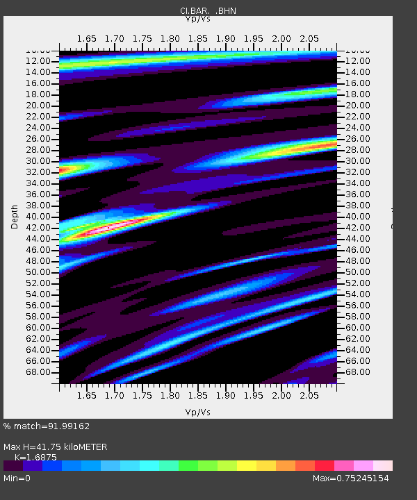
| Estimated Moho Depth: |
41.75 km |
| Estimated Crust Vp/Vs: |
1.69 |
| Assumed Crust Vp: |
6.264 km/s |
| Estimated Crust Vs: |
3.712 km/s |
| Estimated Crust Poisson's Ratio: |
0.23 |
|
| Radial Match: |
91.99162 % |
| Radial Bump: |
348 |
| Transverse Match: |
81.45195 % |
| Transverse Bump: |
400 |
| SOD ConfigId: |
3753 |
| Insert Time: |
2010-02-26 00:06:45.427 +0000 |
| GWidth: |
2.5 |
| Max Bumps: |
400 |
| Tol: |
0.001 |
|

Signal To Noise
| Channel | StoN | STA | LTA |
| CI:BAR: :BHN:20010110T16:09:02.286Z | 3.3314478 | 8.789286E-7 | 2.638278E-7 |
| CI:BAR: :BHE:20010110T16:09:02.286Z | 1.4413607 | 7.716404E-7 | 5.353555E-7 |
| CI:BAR: :BHZ:20010110T16:09:02.286Z | 2.2988434 | 1.4379913E-6 | 6.255282E-7 |
| Arrivals |
| Ps | 4.9 SECOND |
| PpPs | 17 SECOND |
| PsPs/PpSs | 22 SECOND |


