You are here: Home > Network List > CB - China National Seismic Network Stations List
> Station DL2 Dalian,Liaoning Province > Earthquake Result Viewer
DL2 Dalian,Liaoning Province - Earthquake Result Viewer
| Earthquake location: |
Solomon Islands |
| Earthquake latitude/longitude: |
-6.6/154.7 |
| Earthquake time(UTC): |
2016/02/08 (039) 16:19:13 GMT |
| Earthquake Depth: |
32 km |
| Earthquake Magnitude: |
6.4 MWW, 6.3 MWB, 6.7 MI |
| Earthquake Catalog/Contributor: |
NEIC PDE/NEIC COMCAT |
|
| Network: |
CB China National Seismic Network |
| Station: |
DL2 Dalian,Liaoning Province |
| Lat/Lon: |
38.91 N/121.63 E |
| Elevation: |
65 m |
|
| Distance: |
54.7 deg |
| Az: |
328.549 deg |
| Baz: |
138.369 deg |
| Ray Param: |
0.06522516 |
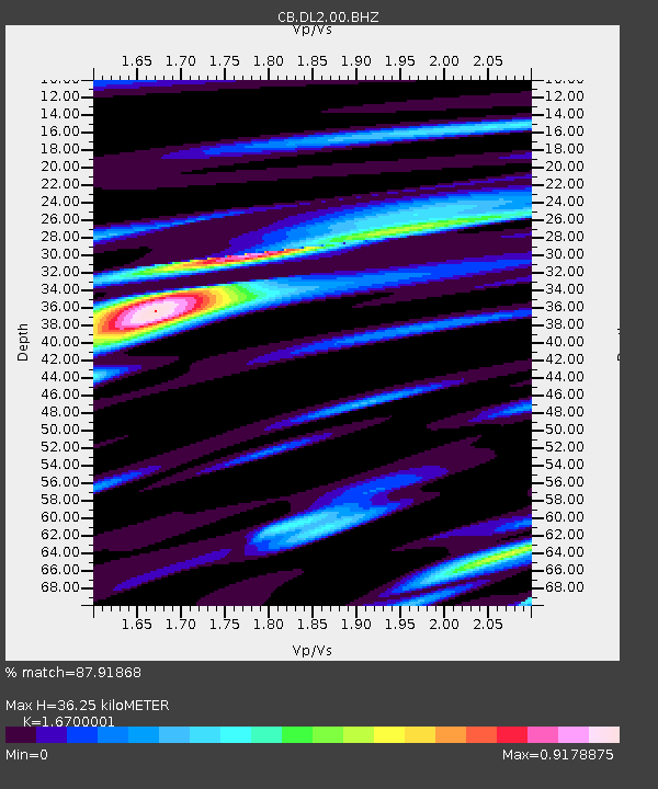
| Estimated Moho Depth: |
36.25 km |
| Estimated Crust Vp/Vs: |
1.67 |
| Assumed Crust Vp: |
6.134 km/s |
| Estimated Crust Vs: |
3.673 km/s |
| Estimated Crust Poisson's Ratio: |
0.22 |
|
| Radial Match: |
87.91868 % |
| Radial Bump: |
400 |
| Transverse Match: |
63.241917 % |
| Transverse Bump: |
400 |
| SOD ConfigId: |
7422571 |
| Insert Time: |
2019-04-21 21:48:13.754 +0000 |
| GWidth: |
2.5 |
| Max Bumps: |
400 |
| Tol: |
0.001 |
|

Signal To Noise
| Channel | StoN | STA | LTA |
| CB:DL2:00:BHZ:20160208T16:28:08.519993Z | 8.939278 | 2.2166214E-6 | 2.4796424E-7 |
| CB:DL2:00:BHN:20160208T16:28:08.519993Z | 4.368916 | 9.234471E-7 | 2.1136755E-7 |
| CB:DL2:00:BHE:20160208T16:28:08.519993Z | 3.9326398 | 7.7551556E-7 | 1.9719974E-7 |
| Arrivals |
| Ps | 4.2 SECOND |
| PpPs | 15 SECOND |
| PsPs/PpSs | 19 SECOND |


