You are here: Home > Network List > CB - China National Seismic Network Stations List
> Station TIA Taian,Shandong Province > Earthquake Result Viewer
TIA Taian,Shandong Province - Earthquake Result Viewer
| Earthquake location: |
Solomon Islands |
| Earthquake latitude/longitude: |
-6.6/154.7 |
| Earthquake time(UTC): |
2016/02/08 (039) 16:19:13 GMT |
| Earthquake Depth: |
32 km |
| Earthquake Magnitude: |
6.4 MWW, 6.3 MWB, 6.7 MI |
| Earthquake Catalog/Contributor: |
NEIC PDE/NEIC COMCAT |
|
| Network: |
CB China National Seismic Network |
| Station: |
TIA Taian,Shandong Province |
| Lat/Lon: |
36.21 N/117.12 E |
| Elevation: |
267 m |
|
| Distance: |
55.3 deg |
| Az: |
323.131 deg |
| Baz: |
132.524 deg |
| Ray Param: |
0.06482879 |
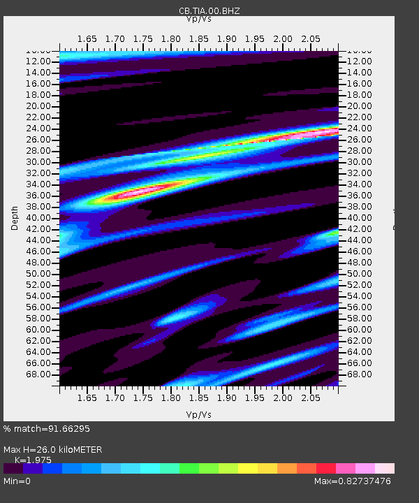
| Estimated Moho Depth: |
26.0 km |
| Estimated Crust Vp/Vs: |
1.98 |
| Assumed Crust Vp: |
6.363 km/s |
| Estimated Crust Vs: |
3.222 km/s |
| Estimated Crust Poisson's Ratio: |
0.33 |
|
| Radial Match: |
91.66295 % |
| Radial Bump: |
296 |
| Transverse Match: |
70.17728 % |
| Transverse Bump: |
400 |
| SOD ConfigId: |
7422571 |
| Insert Time: |
2019-04-21 21:48:20.319 +0000 |
| GWidth: |
2.5 |
| Max Bumps: |
400 |
| Tol: |
0.001 |
|

Signal To Noise
| Channel | StoN | STA | LTA |
| CB:TIA:00:BHZ:20160208T16:28:12.809971Z | 17.272638 | 2.6051484E-6 | 1.5082516E-7 |
| CB:TIA:00:BHN:20160208T16:28:12.809971Z | 11.152736 | 1.0284813E-6 | 9.221784E-8 |
| CB:TIA:00:BHE:20160208T16:28:12.809971Z | 12.176658 | 1.1117003E-6 | 9.129766E-8 |
| Arrivals |
| Ps | 4.2 SECOND |
| PpPs | 12 SECOND |
| PsPs/PpSs | 16 SECOND |


