You are here: Home > Network List > CI - Caltech Regional Seismic Network Stations List
> Station LRL Laurel Mtn Radio Fac, Ridgecrest, CA, USA > Earthquake Result Viewer
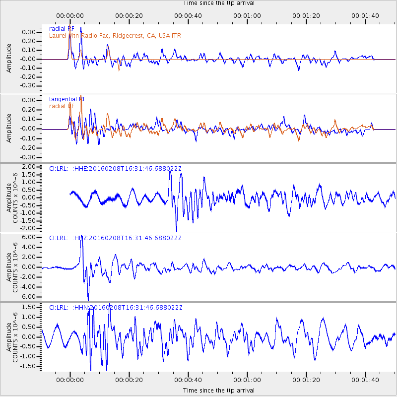
LRL Laurel Mtn Radio Fac, Ridgecrest, CA, USA - Earthquake Result Viewer
*The percent match for this event was below the threshold and hence no stack was calculated.
| Earthquake location: |
Solomon Islands |
| Earthquake latitude/longitude: |
-6.6/154.7 |
| Earthquake time(UTC): |
2016/02/08 (039) 16:19:13 GMT |
| Earthquake Depth: |
32 km |
| Earthquake Magnitude: |
6.4 MWW, 6.3 MWB, 6.7 MI |
| Earthquake Catalog/Contributor: |
NEIC PDE/NEIC COMCAT |
|
| Network: |
CI Caltech Regional Seismic Network |
| Station: |
LRL Laurel Mtn Radio Fac, Ridgecrest, CA, USA |
| Lat/Lon: |
35.48 N/117.68 W |
| Elevation: |
1340 m |
|
| Distance: |
91.9 deg |
| Az: |
54.674 deg |
| Baz: |
263.253 deg |
| Ray Param: |
$rayparam |
*The percent match for this event was below the threshold and hence was not used in the summary stack. |
|
| Radial Match: |
80.39156 % |
| Radial Bump: |
400 |
| Transverse Match: |
73.42623 % |
| Transverse Bump: |
400 |
| SOD ConfigId: |
7422571 |
| Insert Time: |
2019-04-21 21:48:57.945 +0000 |
| GWidth: |
2.5 |
| Max Bumps: |
400 |
| Tol: |
0.001 |
|
Signal To Noise
| Channel | StoN | STA | LTA |
| CI:LRL: :HHZ:20160208T16:31:46.688022Z | 14.971773 | 2.4267113E-6 | 1.6208575E-7 |
| CI:LRL: :HHN:20160208T16:31:46.688022Z | 1.0890571 | 3.188576E-7 | 2.9278317E-7 |
| CI:LRL: :HHE:20160208T16:31:46.688022Z | 2.1482186 | 6.632778E-7 | 3.087571E-7 |
| Arrivals |
| Ps | |
| PpPs | |
| PsPs/PpSs | |


