You are here: Home > Network List > ER - Mount Erebus Volcano Observatory Seismic Network Stations List
> Station ICE Mt Erebus site ICE > Earthquake Result Viewer
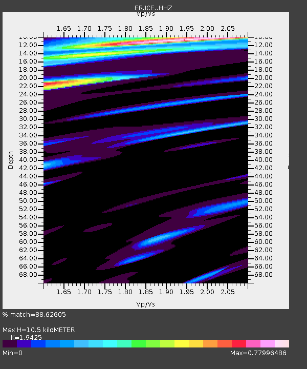
ICE Mt Erebus site ICE - Earthquake Result Viewer
| Earthquake location: |
Solomon Islands |
| Earthquake latitude/longitude: |
-6.6/154.7 |
| Earthquake time(UTC): |
2016/02/08 (039) 16:19:13 GMT |
| Earthquake Depth: |
32 km |
| Earthquake Magnitude: |
6.4 MWW, 6.3 MWB, 6.7 MI |
| Earthquake Catalog/Contributor: |
NEIC PDE/NEIC COMCAT |
|
| Network: |
ER Mount Erebus Volcano Observatory Seismic Network |
| Station: |
ICE Mt Erebus site ICE |
| Lat/Lon: |
77.55 S/167.28 E |
| Elevation: |
2370 m |
|
| Distance: |
71.2 deg |
| Az: |
177.14 deg |
| Baz: |
346.793 deg |
| Ray Param: |
0.05443545 |
| Estimated Moho Depth: |
10.5 km |
| Estimated Crust Vp/Vs: |
1.94 |
| Assumed Crust Vp: |
6.183 km/s |
| Estimated Crust Vs: |
3.183 km/s |
| Estimated Crust Poisson's Ratio: |
0.32 |
|
| Radial Match: |
88.62605 % |
| Radial Bump: |
400 |
| Transverse Match: |
78.65582 % |
| Transverse Bump: |
400 |
| SOD ConfigId: |
7422571 |
| Insert Time: |
2019-04-21 21:49:49.539 +0000 |
| GWidth: |
2.5 |
| Max Bumps: |
400 |
| Tol: |
0.001 |
|

Signal To Noise
| Channel | StoN | STA | LTA |
| ER:ICE: :HHZ:20160208T16:29:57.959019Z | 5.3898554 | 3.0407602E-6 | 5.641636E-7 |
| ER:ICE: :HH1:20160208T16:29:57.959019Z | 3.8641572 | 1.1810185E-6 | 3.056342E-7 |
| ER:ICE: :HH2:20160208T16:29:57.959019Z | 1.593791 | 6.6274896E-7 | 4.1583178E-7 |
| Arrivals |
| Ps | 1.6 SECOND |
| PpPs | 4.8 SECOND |
| PsPs/PpSs | 6.5 SECOND |


