You are here: Home > Network List > JP - Japan Meteorological Agency Seismic Network Stations List
> Station JOW Okinawa Kunigami > Earthquake Result Viewer
JOW Okinawa Kunigami - Earthquake Result Viewer
| Earthquake location: |
Solomon Islands |
| Earthquake latitude/longitude: |
-6.6/154.7 |
| Earthquake time(UTC): |
2016/02/08 (039) 16:19:13 GMT |
| Earthquake Depth: |
32 km |
| Earthquake Magnitude: |
6.4 MWW, 6.3 MWB, 6.7 MI |
| Earthquake Catalog/Contributor: |
NEIC PDE/NEIC COMCAT |
|
| Network: |
JP Japan Meteorological Agency Seismic Network |
| Station: |
JOW Okinawa Kunigami |
| Lat/Lon: |
26.84 N/128.27 E |
| Elevation: |
220 m |
|
| Distance: |
42.0 deg |
| Az: |
323.508 deg |
| Baz: |
138.608 deg |
| Ray Param: |
0.073384084 |
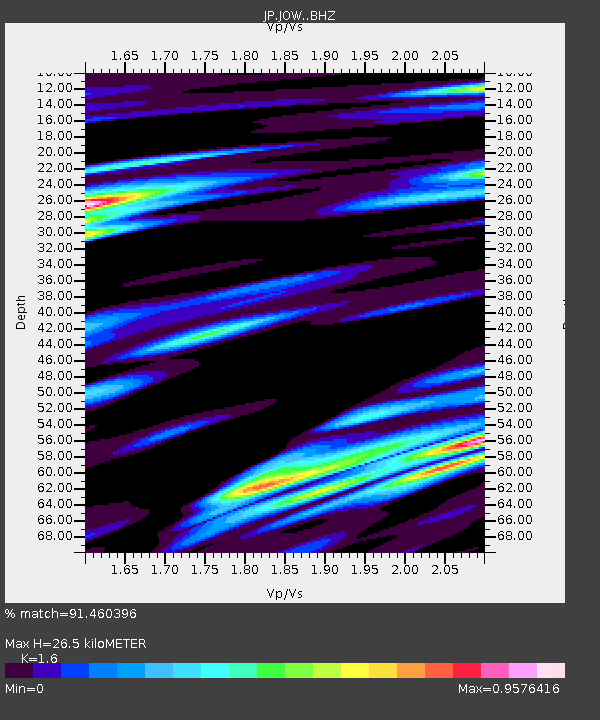
| Estimated Moho Depth: |
26.5 km |
| Estimated Crust Vp/Vs: |
1.60 |
| Assumed Crust Vp: |
6.183 km/s |
| Estimated Crust Vs: |
3.864 km/s |
| Estimated Crust Poisson's Ratio: |
0.18 |
|
| Radial Match: |
91.460396 % |
| Radial Bump: |
400 |
| Transverse Match: |
69.58268 % |
| Transverse Bump: |
400 |
| SOD ConfigId: |
7422571 |
| Insert Time: |
2019-04-21 21:50:20.269 +0000 |
| GWidth: |
2.5 |
| Max Bumps: |
400 |
| Tol: |
0.001 |
|

Signal To Noise
| Channel | StoN | STA | LTA |
| JP:JOW: :BHZ:20160208T16:26:30.649998Z | 14.086144 | 3.091153E-6 | 2.1944635E-7 |
| JP:JOW: :BHN:20160208T16:26:30.649998Z | 3.017337 | 1.3684245E-6 | 4.5352058E-7 |
| JP:JOW: :BHE:20160208T16:26:30.649998Z | 2.3051858 | 8.717983E-7 | 3.7819004E-7 |
| Arrivals |
| Ps | 2.8 SECOND |
| PpPs | 10 SECOND |
| PsPs/PpSs | 13 SECOND |


