You are here: Home > Network List > TA - USArray Transportable Network (new EarthScope stations) Stations List
> Station G05D Wamic, OR, USA > Earthquake Result Viewer
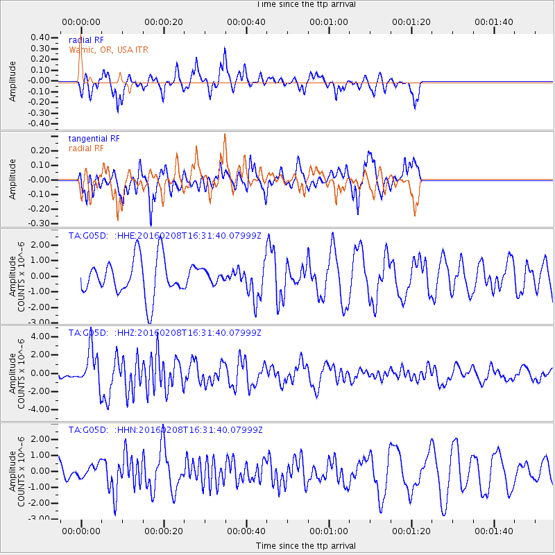
G05D Wamic, OR, USA - Earthquake Result Viewer
*The percent match for this event was below the threshold and hence no stack was calculated.
| Earthquake location: |
Solomon Islands |
| Earthquake latitude/longitude: |
-6.6/154.7 |
| Earthquake time(UTC): |
2016/02/08 (039) 16:19:13 GMT |
| Earthquake Depth: |
32 km |
| Earthquake Magnitude: |
6.4 MWW, 6.3 MWB, 6.7 MI |
| Earthquake Catalog/Contributor: |
NEIC PDE/NEIC COMCAT |
|
| Network: |
TA USArray Transportable Network (new EarthScope stations) |
| Station: |
G05D Wamic, OR, USA |
| Lat/Lon: |
45.24 N/121.32 W |
| Elevation: |
592 m |
|
| Distance: |
90.4 deg |
| Az: |
44.637 deg |
| Baz: |
261.1 deg |
| Ray Param: |
$rayparam |
*The percent match for this event was below the threshold and hence was not used in the summary stack. |
|
| Radial Match: |
46.059788 % |
| Radial Bump: |
333 |
| Transverse Match: |
56.114227 % |
| Transverse Bump: |
336 |
| SOD ConfigId: |
7422571 |
| Insert Time: |
2019-04-21 21:52:02.035 +0000 |
| GWidth: |
2.5 |
| Max Bumps: |
400 |
| Tol: |
0.001 |
|
Signal To Noise
| Channel | StoN | STA | LTA |
| TA:G05D: :HHZ:20160208T16:31:40.07999Z | 2.9352841 | 2.0899283E-6 | 7.120021E-7 |
| TA:G05D: :HHN:20160208T16:31:40.07999Z | 0.36525878 | 4.0956877E-7 | 1.1213111E-6 |
| TA:G05D: :HHE:20160208T16:31:40.07999Z | 0.31704178 | 3.8544164E-7 | 1.215744E-6 |
| Arrivals |
| Ps | |
| PpPs | |
| PsPs/PpSs | |


