You are here: Home > Network List > UW - Pacific Northwest Regional Seismic Network Stations List
> Station LEBA Lebam, WA, USA > Earthquake Result Viewer
LEBA Lebam, WA, USA - Earthquake Result Viewer
*The percent match for this event was below the threshold and hence no stack was calculated.
| Earthquake location: |
Solomon Islands |
| Earthquake latitude/longitude: |
-6.6/154.7 |
| Earthquake time(UTC): |
2016/02/08 (039) 16:19:13 GMT |
| Earthquake Depth: |
32 km |
| Earthquake Magnitude: |
6.4 MWW, 6.3 MWB, 6.7 MI |
| Earthquake Catalog/Contributor: |
NEIC PDE/NEIC COMCAT |
|
| Network: |
UW Pacific Northwest Regional Seismic Network |
| Station: |
LEBA Lebam, WA, USA |
| Lat/Lon: |
46.55 N/123.56 W |
| Elevation: |
73 m |
|
| Distance: |
89.1 deg |
| Az: |
43.087 deg |
| Baz: |
259.485 deg |
| Ray Param: |
$rayparam |
*The percent match for this event was below the threshold and hence was not used in the summary stack. |
|
| Radial Match: |
69.11801 % |
| Radial Bump: |
400 |
| Transverse Match: |
56.494038 % |
| Transverse Bump: |
400 |
| SOD ConfigId: |
7422571 |
| Insert Time: |
2019-04-21 21:53:24.497 +0000 |
| GWidth: |
2.5 |
| Max Bumps: |
400 |
| Tol: |
0.001 |
|
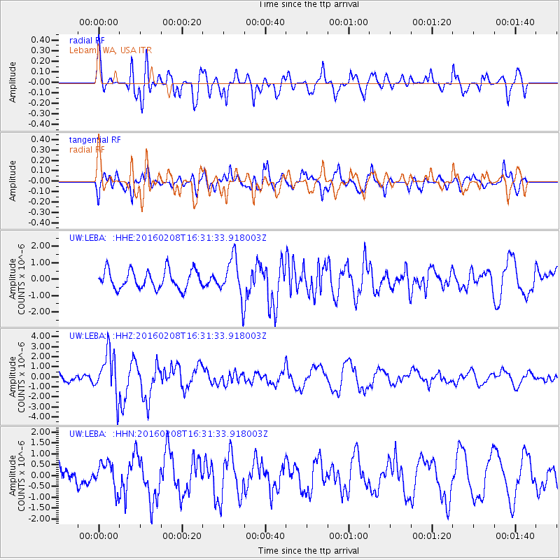
Signal To Noise
| Channel | StoN | STA | LTA |
| UW:LEBA: :HHZ:20160208T16:31:33.918003Z | 3.6324298 | 2.2739598E-6 | 6.260162E-7 |
| UW:LEBA: :HHN:20160208T16:31:33.918003Z | 1.1032089 | 6.40653E-7 | 5.8071777E-7 |
| UW:LEBA: :HHE:20160208T16:31:33.918003Z | 2.2242055 | 1.2632412E-6 | 5.679517E-7 |
| Arrivals |
| Ps | |
| PpPs | |
| PsPs/PpSs | |


