You are here: Home > Network List > UW - Pacific Northwest Regional Seismic Network Stations List
> Station WOLL Wollman Farm, Schrag, WA, USA > Earthquake Result Viewer
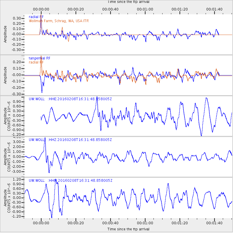
WOLL Wollman Farm, Schrag, WA, USA - Earthquake Result Viewer
*The percent match for this event was below the threshold and hence no stack was calculated.
| Earthquake location: |
Solomon Islands |
| Earthquake latitude/longitude: |
-6.6/154.7 |
| Earthquake time(UTC): |
2016/02/08 (039) 16:19:13 GMT |
| Earthquake Depth: |
32 km |
| Earthquake Magnitude: |
6.4 MWW, 6.3 MWB, 6.7 MI |
| Earthquake Catalog/Contributor: |
NEIC PDE/NEIC COMCAT |
|
| Network: |
UW Pacific Northwest Regional Seismic Network |
| Station: |
WOLL Wollman Farm, Schrag, WA, USA |
| Lat/Lon: |
47.06 N/118.92 W |
| Elevation: |
385 m |
|
| Distance: |
92.3 deg |
| Az: |
43.071 deg |
| Baz: |
262.86 deg |
| Ray Param: |
$rayparam |
*The percent match for this event was below the threshold and hence was not used in the summary stack. |
|
| Radial Match: |
66.254486 % |
| Radial Bump: |
379 |
| Transverse Match: |
53.10586 % |
| Transverse Bump: |
400 |
| SOD ConfigId: |
7422571 |
| Insert Time: |
2019-04-21 21:53:32.254 +0000 |
| GWidth: |
2.5 |
| Max Bumps: |
400 |
| Tol: |
0.001 |
|
Signal To Noise
| Channel | StoN | STA | LTA |
| UW:WOLL: :HHZ:20160208T16:31:48.858005Z | 6.72687 | 1.7731064E-6 | 2.6358563E-7 |
| UW:WOLL: :HHN:20160208T16:31:48.858005Z | 1.0625767 | 4.4884305E-7 | 4.2241004E-7 |
| UW:WOLL: :HHE:20160208T16:31:48.858005Z | 2.6301968 | 5.6371823E-7 | 2.1432551E-7 |
| Arrivals |
| Ps | |
| PpPs | |
| PsPs/PpSs | |


