You are here: Home > Network List > XD14 - Illuminating the architecture of the greater Mount St. Helens magmatic systems f Stations List
> Station ME03 "Mount St Helens, WA" > Earthquake Result Viewer
ME03 "Mount St Helens, WA" - Earthquake Result Viewer
| Earthquake location: |
Solomon Islands |
| Earthquake latitude/longitude: |
-6.6/154.7 |
| Earthquake time(UTC): |
2016/02/08 (039) 16:19:13 GMT |
| Earthquake Depth: |
32 km |
| Earthquake Magnitude: |
6.4 MWW, 6.3 MWB, 6.7 MI |
| Earthquake Catalog/Contributor: |
NEIC PDE/NEIC COMCAT |
|
| Network: |
XD Illuminating the architecture of the greater Mount St. Helens magmatic systems f |
| Station: |
ME03 "Mount St Helens, WA" |
| Lat/Lon: |
46.45 N/122.58 W |
| Elevation: |
310 m |
|
| Distance: |
89.8 deg |
| Az: |
43.3 deg |
| Baz: |
260.201 deg |
| Ray Param: |
0.041718554 |
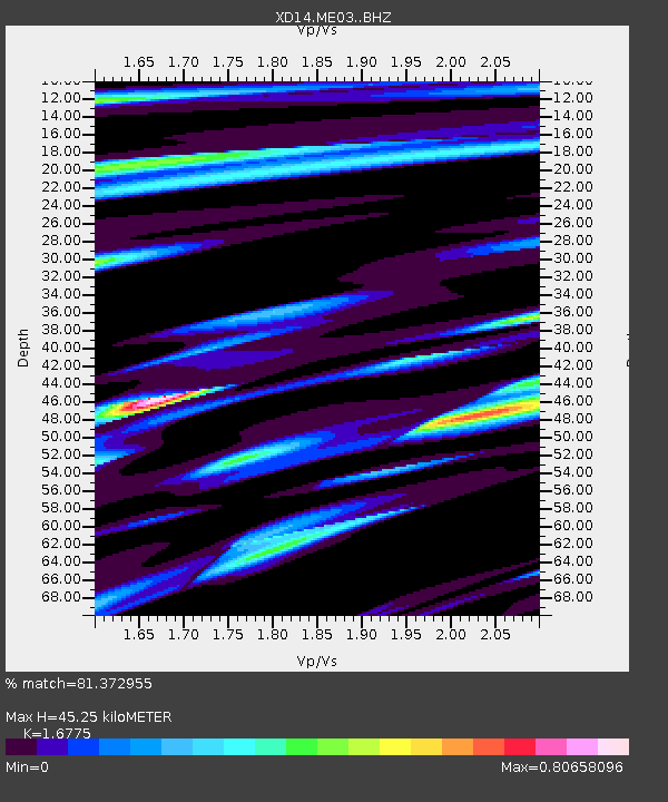
| Estimated Moho Depth: |
45.25 km |
| Estimated Crust Vp/Vs: |
1.68 |
| Assumed Crust Vp: |
6.566 km/s |
| Estimated Crust Vs: |
3.914 km/s |
| Estimated Crust Poisson's Ratio: |
0.22 |
|
| Radial Match: |
81.372955 % |
| Radial Bump: |
369 |
| Transverse Match: |
62.63564 % |
| Transverse Bump: |
400 |
| SOD ConfigId: |
7422571 |
| Insert Time: |
2019-04-21 21:53:44.578 +0000 |
| GWidth: |
2.5 |
| Max Bumps: |
400 |
| Tol: |
0.001 |
|

Signal To Noise
| Channel | StoN | STA | LTA |
| XD:ME03: :BHZ:20160208T16:31:36.97501Z | 4.56069 | 2.7046644E-6 | 5.930384E-7 |
| XD:ME03: :BHN:20160208T16:31:36.97501Z | 0.83870834 | 5.003916E-7 | 5.966217E-7 |
| XD:ME03: :BHE:20160208T16:31:36.97501Z | 0.9230749 | 3.9619604E-7 | 4.2921332E-7 |
| Arrivals |
| Ps | 4.8 SECOND |
| PpPs | 18 SECOND |
| PsPs/PpSs | 23 SECOND |


