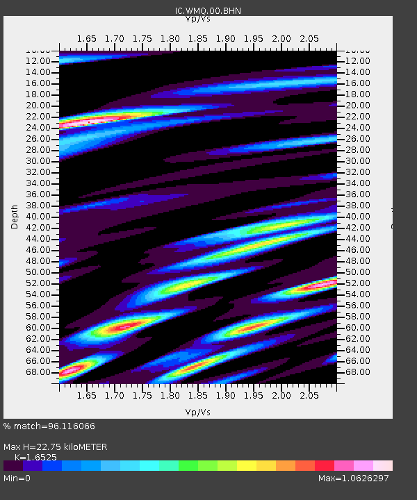
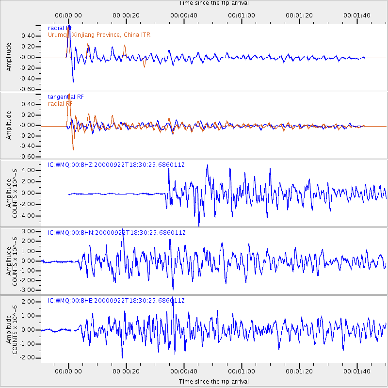
WMQ Urumqi, Xinjiang Province, China - Earthquake Result Viewer

Earthquake location: Southern Sumatra, Indonesia
Earthquake latitude/longitude: -5.0/102.1
Earthquake time(UTC): 2000/09/22 (266) 18:22:03 GMT
Earthquake Depth: 33 km
Earthquake Magnitude: 5.8 MB, 5.9 MS, 6.2 MW, 6.2 MW
Earthquake Catalog/Contributor: WHDF/NEIC
Network: IC New China Digital Seismograph Network
Station: WMQ Urumqi, Xinjiang Province, China
Lat/Lon: 43.82 N/87.69 E
Elevation: 903 m
Distance: 50.3 deg
Az: 346.456 deg
Baz: 161.194 deg
Ray Param: 0.068104304
Estimated Moho Depth: 22.75 km
Estimated Crust Vp/Vs: 1.65
Assumed Crust Vp: 6.242 km/s
Estimated Crust Vs: 3.777 km/s
Estimated Crust Poisson's Ratio: 0.21
Radial Match: 96.116066 %
Radial Bump: 400
Transverse Match: 91.07756 %
Transverse Bump: 400
SOD ConfigId: 3744
Insert Time: 2010-03-04 23:56:05.176 +0000
GWidth: 2.5
Max Bumps: 400
Tol: 0.001

Signal To Noise

ChannelStoNSTALTA
IC:WMQ:00:BHN:20000922T18:30:25.686011Z3.84040472.4554762E-76.3937954E-8
IC:WMQ:00:BHE:20000922T18:30:25.686011Z3.19066981.3738318E-74.305779E-8
IC:WMQ:00:BHZ:20000922T18:30:25.686011Z18.7794021.0103519E-65.3801067E-8
Arrivals
Ps2.5 SECOND
PpPs9.1 SECOND
PsPs/PpSs12 SECOND