You are here: Home > Network List > YT07 - POLENET Stations List
> Station MA10 Polenet mini-array MA10 > Earthquake Result Viewer
MA10 Polenet mini-array MA10 - Earthquake Result Viewer
| Earthquake location: |
Solomon Islands |
| Earthquake latitude/longitude: |
-6.6/154.7 |
| Earthquake time(UTC): |
2016/02/08 (039) 16:19:13 GMT |
| Earthquake Depth: |
32 km |
| Earthquake Magnitude: |
6.4 MWW, 6.3 MWB, 6.7 MI |
| Earthquake Catalog/Contributor: |
NEIC PDE/NEIC COMCAT |
|
| Network: |
YT POLENET |
| Station: |
MA10 Polenet mini-array MA10 |
| Lat/Lon: |
78.60 S/109.00 W |
| Elevation: |
1658 m |
|
| Distance: |
84.8 deg |
| Az: |
168.547 deg |
| Baz: |
262.529 deg |
| Ray Param: |
0.045180526 |
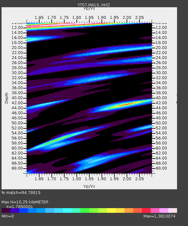
| Estimated Moho Depth: |
10.25 km |
| Estimated Crust Vp/Vs: |
1.79 |
| Assumed Crust Vp: |
5.872 km/s |
| Estimated Crust Vs: |
3.29 km/s |
| Estimated Crust Poisson's Ratio: |
0.27 |
|
| Radial Match: |
94.78815 % |
| Radial Bump: |
400 |
| Transverse Match: |
89.40142 % |
| Transverse Bump: |
373 |
| SOD ConfigId: |
7422571 |
| Insert Time: |
2019-04-21 21:56:05.156 +0000 |
| GWidth: |
2.5 |
| Max Bumps: |
400 |
| Tol: |
0.001 |
|

Signal To Noise
| Channel | StoN | STA | LTA |
| YT:MA10: :HHZ:20160208T16:31:13.118992Z | 18.648449 | 3.6242516E-6 | 1.9434601E-7 |
| YT:MA10: :HHN:20160208T16:31:13.118992Z | 2.242582 | 4.6563332E-7 | 2.0763268E-7 |
| YT:MA10: :HHE:20160208T16:31:13.118992Z | 4.2452774 | 1.1579631E-6 | 2.72765E-7 |
| Arrivals |
| Ps | 1.4 SECOND |
| PpPs | 4.8 SECOND |
| PsPs/PpSs | 6.2 SECOND |


