You are here: Home > Network List > YT07 - POLENET Stations List
> Station MECK MECK > Earthquake Result Viewer
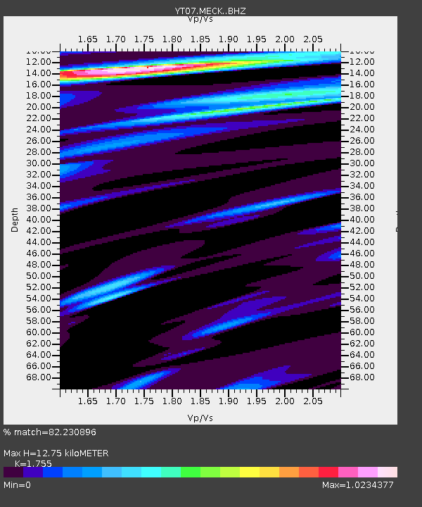
MECK MECK - Earthquake Result Viewer
| Earthquake location: |
Solomon Islands |
| Earthquake latitude/longitude: |
-6.6/154.7 |
| Earthquake time(UTC): |
2016/02/08 (039) 16:19:13 GMT |
| Earthquake Depth: |
32 km |
| Earthquake Magnitude: |
6.4 MWW, 6.3 MWB, 6.7 MI |
| Earthquake Catalog/Contributor: |
NEIC PDE/NEIC COMCAT |
|
| Network: |
YT POLENET |
| Station: |
MECK MECK |
| Lat/Lon: |
75.28 S/72.18 W |
| Elevation: |
1086 m |
|
| Distance: |
93.6 deg |
| Az: |
169.22 deg |
| Baz: |
226.611 deg |
| Ray Param: |
0.041217968 |
| Estimated Moho Depth: |
12.75 km |
| Estimated Crust Vp/Vs: |
1.75 |
| Assumed Crust Vp: |
6.338 km/s |
| Estimated Crust Vs: |
3.611 km/s |
| Estimated Crust Poisson's Ratio: |
0.26 |
|
| Radial Match: |
82.230896 % |
| Radial Bump: |
339 |
| Transverse Match: |
61.031136 % |
| Transverse Bump: |
400 |
| SOD ConfigId: |
7422571 |
| Insert Time: |
2019-04-21 21:56:05.636 +0000 |
| GWidth: |
2.5 |
| Max Bumps: |
400 |
| Tol: |
0.001 |
|

Signal To Noise
| Channel | StoN | STA | LTA |
| YT:MECK: :BHZ:20160208T16:31:54.72501Z | 3.085776 | 2.2364782E-6 | 7.2477E-7 |
| YT:MECK: :BHN:20160208T16:31:54.72501Z | 1.3368349 | 1.0457603E-6 | 7.822659E-7 |
| YT:MECK: :BHE:20160208T16:31:54.72501Z | 1.9677899 | 5.57343E-7 | 2.83233E-7 |
| Arrivals |
| Ps | 1.5 SECOND |
| PpPs | 5.4 SECOND |
| PsPs/PpSs | 7.0 SECOND |


