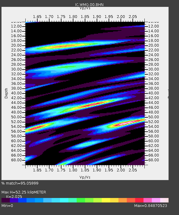
WMQ Urumqi, Xinjiang Province, China - Earthquake Result Viewer

Earthquake location: New Britain Region, P.N.G.
Earthquake latitude/longitude: -5.1/152.5
Earthquake time(UTC): 2000/06/09 (161) 01:27:15 GMT
Earthquake Depth: 33 km
Earthquake Magnitude: 5.4 MB, 6.3 MS, 6.3 MW, 6.3 MW
Earthquake Catalog/Contributor: WHDF/NEIC
Network: IC New China Digital Seismograph Network
Station: WMQ Urumqi, Xinjiang Province, China
Lat/Lon: 43.82 N/87.69 E
Elevation: 903 m
Distance: 75.7 deg
Az: 317.486 deg
Baz: 111.564 deg
Ray Param: 0.051421423
Estimated Moho Depth: 52.25 km
Estimated Crust Vp/Vs: 2.03
Assumed Crust Vp: 6.242 km/s
Estimated Crust Vs: 3.082 km/s
Estimated Crust Poisson's Ratio: 0.34
Radial Match: 95.05999 %
Radial Bump: 399
Transverse Match: 88.18695 %
Transverse Bump: 400
SOD ConfigId: 3744
Insert Time: 2010-03-04 23:56:29.351 +0000
GWidth: 2.5
Max Bumps: 400
Tol: 0.001

Signal To Noise

ChannelStoNSTALTA
IC:WMQ:00:BHN:20000609T01:38:26.459011Z1.95485859.4797045E-84.8493046E-8
IC:WMQ:00:BHE:20000609T01:38:26.459011Z2.6712721.1057622E-74.1394593E-8
IC:WMQ:00:BHZ:20000609T01:38:26.459011Z5.55403663.1002912E-75.5820504E-8
Arrivals
Ps8.8 SECOND
PpPs25 SECOND
PsPs/PpSs33 SECOND