POKR Poker Plat Research Range, AK, USA - Earthquake Result Viewer
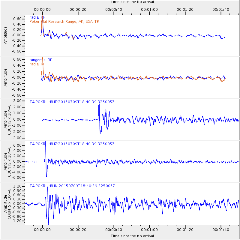
Earthquake location: Near East Coast Of Honshu, Japan
Earthquake latitude/longitude: 40.4/141.5
Earthquake time(UTC): 2015/07/09 (190) 18:32:51 GMT
Earthquake Depth: 79 km
Earthquake Magnitude: 5.6 MWB, 5.5 MWW, 5.6 MWR, 5.6 MWC
Earthquake Catalog/Contributor: NEIC PDE/NEIC COMCAT
Network: TA USArray Transportable Network (new EarthScope stations)
Station: POKR Poker Plat Research Range, AK, USA
Lat/Lon: 65.12 N/147.43 W
Elevation: 501 m
Distance: 46.4 deg
Az: 33.538 deg
Baz: 273.843 deg
Ray Param: 0.07040454
Estimated Moho Depth: 25.5 km
Estimated Crust Vp/Vs: 1.99
Assumed Crust Vp: 6.566 km/s
Estimated Crust Vs: 3.308 km/s
Estimated Crust Poisson's Ratio: 0.33
Radial Match: 90.84773 %
Radial Bump: 400
Transverse Match: 84.028694 %
Transverse Bump: 400
SOD ConfigId: 1080791
Insert Time: 2015-07-23 20:42:56.145 +0000
GWidth: 2.5
Max Bumps: 400
Tol: 0.001

Signal To Noise

ChannelStoNSTALTA
TA:POKR: :BHZ:20150709T18:40:39.325005Z31.6100622.4292583E-67.6850796E-8
TA:POKR: :BHN:20150709T18:40:39.325005Z10.7844525.0172355E-74.652286E-8
TA:POKR: :BHE:20150709T18:40:39.325005Z17.9623951.1669479E-66.496616E-8
Arrivals
Ps4.1 SECOND
PpPs11 SECOND
PsPs/PpSs15 SECOND