You are here: Home > Network List > IC - New China Digital Seismograph Network Stations List
> Station WMQ Urumqi, Xinjiang Province, China > Earthquake Result Viewer
WMQ Urumqi, Xinjiang Province, China - Earthquake Result Viewer
| Earthquake location: |
Santa Cruz Islands |
| Earthquake latitude/longitude: |
-12.0/166.4 |
| Earthquake time(UTC): |
2000/08/03 (216) 01:09:38 GMT |
| Earthquake Depth: |
33 km |
| Earthquake Magnitude: |
5.7 MB, 6.5 MS, 6.7 MW, 6.6 MW |
| Earthquake Catalog/Contributor: |
WHDF/NEIC |
|
| Network: |
IC New China Digital Seismograph Network |
| Station: |
WMQ Urumqi, Xinjiang Province, China |
| Lat/Lon: |
43.82 N/87.69 E |
| Elevation: |
903 m |
|
| Distance: |
90.3 deg |
| Az: |
314.771 deg |
| Baz: |
106.358 deg |
| Ray Param: |
0.04168078 |
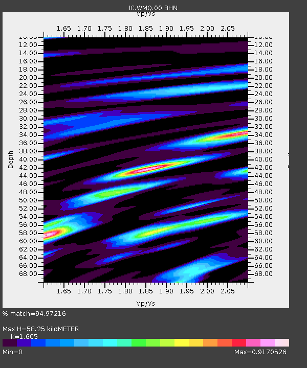
| Estimated Moho Depth: |
58.25 km |
| Estimated Crust Vp/Vs: |
1.61 |
| Assumed Crust Vp: |
6.242 km/s |
| Estimated Crust Vs: |
3.889 km/s |
| Estimated Crust Poisson's Ratio: |
0.18 |
|
| Radial Match: |
94.97216 % |
| Radial Bump: |
400 |
| Transverse Match: |
91.016846 % |
| Transverse Bump: |
400 |
| SOD ConfigId: |
3744 |
| Insert Time: |
2010-03-04 23:57:01.554 +0000 |
| GWidth: |
2.5 |
| Max Bumps: |
400 |
| Tol: |
0.001 |
|

Signal To Noise
| Channel | StoN | STA | LTA |
| IC:WMQ:00:BHN:20000803T01:22:05.135029Z | 4.5013723 | 2.822465E-7 | 6.270233E-8 |
| IC:WMQ:00:BHE:20000803T01:22:05.135029Z | 12.280357 | 5.2341875E-7 | 4.262244E-8 |
| IC:WMQ:00:BHZ:20000803T01:22:05.135029Z | 20.72523 | 1.6903575E-6 | 8.156037E-8 |
| Arrivals |
| Ps | 5.8 SECOND |
| PpPs | 24 SECOND |
| PsPs/PpSs | 30 SECOND |


