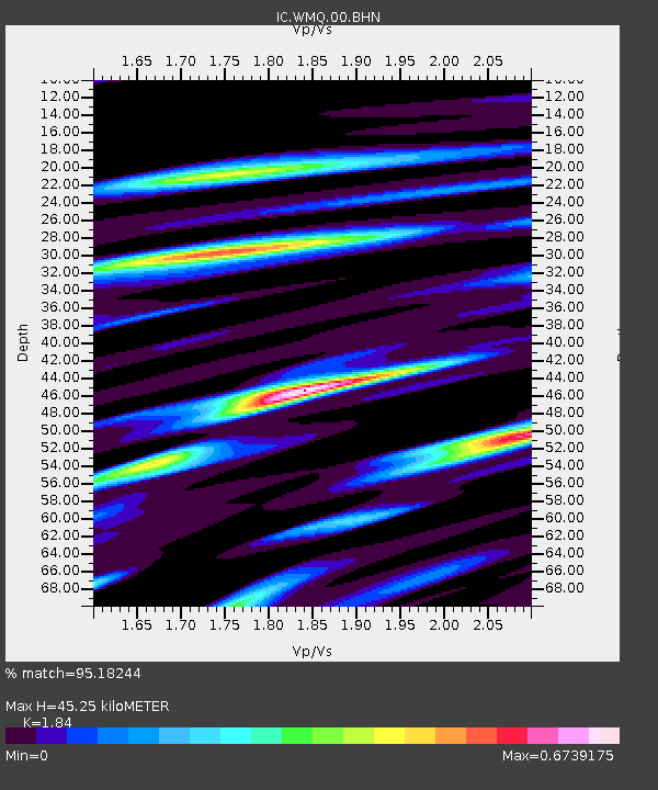
WMQ Urumqi, Xinjiang Province, China - Earthquake Result Viewer
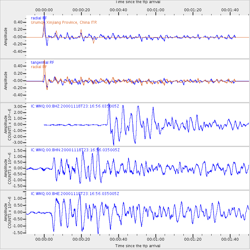
Earthquake location: New Ireland Region, P.N.G.
Earthquake latitude/longitude: -5.4/153.5
Earthquake time(UTC): 2000/11/18 (323) 23:05:39 GMT
Earthquake Depth: 33 km
Earthquake Magnitude: 5.7 MB, 6.0 MS, 6.0 MW, 5.9 MW
Earthquake Catalog/Contributor: WHDF/NEIC
Network: IC New China Digital Seismograph Network
Station: WMQ Urumqi, Xinjiang Province, China
Lat/Lon: 43.82 N/87.69 E
Elevation: 903 m
Distance: 76.6 deg
Az: 317.278 deg
Baz: 111.058 deg
Ray Param: 0.050833188
Estimated Moho Depth: 45.25 km
Estimated Crust Vp/Vs: 1.84
Assumed Crust Vp: 6.242 km/s
Estimated Crust Vs: 3.392 km/s
Estimated Crust Poisson's Ratio: 0.29
Radial Match: 95.18244 %
Radial Bump: 400
Transverse Match: 91.801926 %
Transverse Bump: 400
SOD ConfigId: 3744
Insert Time: 2010-03-04 23:58:19.928 +0000
GWidth: 2.5
Max Bumps: 400
Tol: 0.001

Signal To Noise

ChannelStoNSTALTA
IC:WMQ:00:BHN:20001118T23:16:56.035005Z1.37224691.1153509E-78.127917E-8
IC:WMQ:00:BHE:20001118T23:16:56.035005Z4.28105072.625669E-76.133236E-8
IC:WMQ:00:BHZ:20001118T23:16:56.035005Z16.762028.109079E-74.8377697E-8
Arrivals
Ps6.3 SECOND
PpPs20 SECOND
PsPs/PpSs26 SECOND