You are here: Home > Network List > TA - USArray Transportable Network (new EarthScope stations) Stations List
> Station J05D Fort Rock, OR, USA > Earthquake Result Viewer
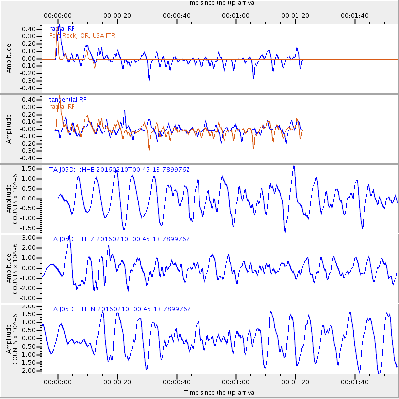
J05D Fort Rock, OR, USA - Earthquake Result Viewer
*The percent match for this event was below the threshold and hence no stack was calculated.
| Earthquake location: |
Near Coast Of Central Chile |
| Earthquake latitude/longitude: |
-30.6/-71.6 |
| Earthquake time(UTC): |
2016/02/10 (041) 00:33:05 GMT |
| Earthquake Depth: |
32 km |
| Earthquake Magnitude: |
6.3 MWB |
| Earthquake Catalog/Contributor: |
NEIC PDE/NEIC COMCAT |
|
| Network: |
TA USArray Transportable Network (new EarthScope stations) |
| Station: |
J05D Fort Rock, OR, USA |
| Lat/Lon: |
43.28 N/121.23 W |
| Elevation: |
1541 m |
|
| Distance: |
86.5 deg |
| Az: |
326.132 deg |
| Baz: |
138.869 deg |
| Ray Param: |
$rayparam |
*The percent match for this event was below the threshold and hence was not used in the summary stack. |
|
| Radial Match: |
47.080944 % |
| Radial Bump: |
360 |
| Transverse Match: |
38.39121 % |
| Transverse Bump: |
286 |
| SOD ConfigId: |
7422571 |
| Insert Time: |
2019-04-21 22:05:02.266 +0000 |
| GWidth: |
2.5 |
| Max Bumps: |
400 |
| Tol: |
0.001 |
|
Signal To Noise
| Channel | StoN | STA | LTA |
| TA:J05D: :HHZ:20160210T00:45:13.789976Z | 3.0405173 | 1.4483785E-6 | 4.7635922E-7 |
| TA:J05D: :HHN:20160210T00:45:13.789976Z | 1.3479894 | 5.0584765E-7 | 3.7526084E-7 |
| TA:J05D: :HHE:20160210T00:45:13.789976Z | 1.140243 | 8.4129545E-7 | 7.3782115E-7 |
| Arrivals |
| Ps | |
| PpPs | |
| PsPs/PpSs | |


