You are here: Home > Network List > TA - USArray Transportable Network (new EarthScope stations) Stations List
> Station N59A State Game Land 141, Hazleton, PA, USA > Earthquake Result Viewer
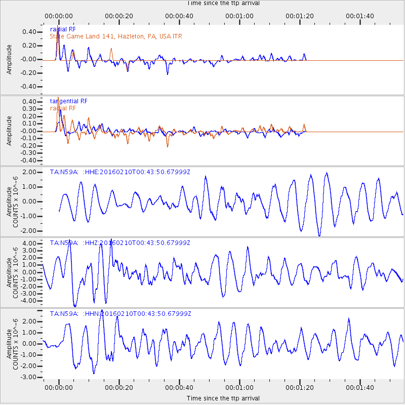
N59A State Game Land 141, Hazleton, PA, USA - Earthquake Result Viewer
*The percent match for this event was below the threshold and hence no stack was calculated.
| Earthquake location: |
Near Coast Of Central Chile |
| Earthquake latitude/longitude: |
-30.6/-71.6 |
| Earthquake time(UTC): |
2016/02/10 (041) 00:33:05 GMT |
| Earthquake Depth: |
32 km |
| Earthquake Magnitude: |
6.3 MWB |
| Earthquake Catalog/Contributor: |
NEIC PDE/NEIC COMCAT |
|
| Network: |
TA USArray Transportable Network (new EarthScope stations) |
| Station: |
N59A State Game Land 141, Hazleton, PA, USA |
| Lat/Lon: |
40.92 N/75.77 W |
| Elevation: |
508 m |
|
| Distance: |
71.3 deg |
| Az: |
356.68 deg |
| Baz: |
176.224 deg |
| Ray Param: |
$rayparam |
*The percent match for this event was below the threshold and hence was not used in the summary stack. |
|
| Radial Match: |
69.90002 % |
| Radial Bump: |
286 |
| Transverse Match: |
57.11707 % |
| Transverse Bump: |
375 |
| SOD ConfigId: |
7422571 |
| Insert Time: |
2019-04-21 22:05:11.855 +0000 |
| GWidth: |
2.5 |
| Max Bumps: |
400 |
| Tol: |
0.001 |
|
Signal To Noise
| Channel | StoN | STA | LTA |
| TA:N59A: :HHZ:20160210T00:43:50.67999Z | 2.482728 | 2.3303012E-6 | 9.386051E-7 |
| TA:N59A: :HHN:20160210T00:43:50.67999Z | 1.5251937 | 1.1284393E-6 | 7.3986627E-7 |
| TA:N59A: :HHE:20160210T00:43:50.67999Z | 0.32963392 | 2.1679598E-7 | 6.576871E-7 |
| Arrivals |
| Ps | |
| PpPs | |
| PsPs/PpSs | |


