You are here: Home > Network List > TA - USArray Transportable Network (new EarthScope stations) Stations List
> Station SFIN Lafayette, IN, USA > Earthquake Result Viewer
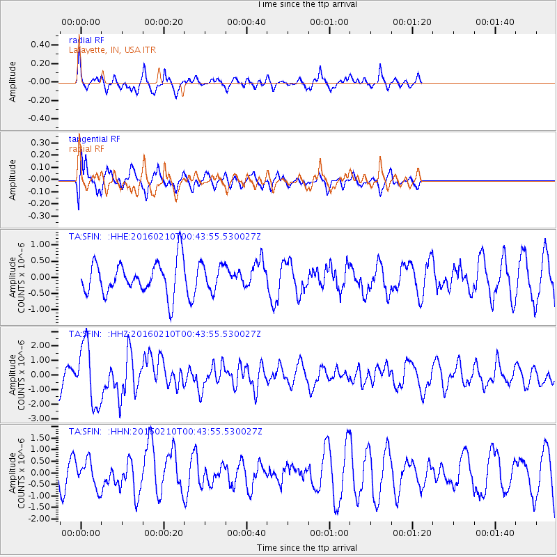
SFIN Lafayette, IN, USA - Earthquake Result Viewer
*The percent match for this event was below the threshold and hence no stack was calculated.
| Earthquake location: |
Near Coast Of Central Chile |
| Earthquake latitude/longitude: |
-30.6/-71.6 |
| Earthquake time(UTC): |
2016/02/10 (041) 00:33:05 GMT |
| Earthquake Depth: |
32 km |
| Earthquake Magnitude: |
6.3 MWB |
| Earthquake Catalog/Contributor: |
NEIC PDE/NEIC COMCAT |
|
| Network: |
TA USArray Transportable Network (new EarthScope stations) |
| Station: |
SFIN Lafayette, IN, USA |
| Lat/Lon: |
40.38 N/87.10 W |
| Elevation: |
165 m |
|
| Distance: |
72.1 deg |
| Az: |
347.63 deg |
| Baz: |
166.013 deg |
| Ray Param: |
$rayparam |
*The percent match for this event was below the threshold and hence was not used in the summary stack. |
|
| Radial Match: |
46.652916 % |
| Radial Bump: |
333 |
| Transverse Match: |
68.79084 % |
| Transverse Bump: |
400 |
| SOD ConfigId: |
7422571 |
| Insert Time: |
2019-04-21 22:05:22.368 +0000 |
| GWidth: |
2.5 |
| Max Bumps: |
400 |
| Tol: |
0.001 |
|
Signal To Noise
| Channel | StoN | STA | LTA |
| TA:SFIN: :HHZ:20160210T00:43:55.530027Z | 2.4327593 | 2.143385E-6 | 8.81051E-7 |
| TA:SFIN: :HHN:20160210T00:43:55.530027Z | 1.1314619 | 6.060322E-7 | 5.3561877E-7 |
| TA:SFIN: :HHE:20160210T00:43:55.530027Z | 0.7546664 | 3.8538843E-7 | 5.106739E-7 |
| Arrivals |
| Ps | |
| PpPs | |
| PsPs/PpSs | |


