You are here: Home > Network List > IC - New China Digital Seismograph Network Stations List
> Station WMQ Urumqi, Xinjiang Province, China > Earthquake Result Viewer
WMQ Urumqi, Xinjiang Province, China - Earthquake Result Viewer
| Earthquake location: |
Off East Coast Of Kamchatka |
| Earthquake latitude/longitude: |
52.1/159.5 |
| Earthquake time(UTC): |
1999/03/08 (067) 12:25:48 GMT |
| Earthquake Depth: |
57 km |
| Earthquake Magnitude: |
5.7 MB, 6.9 MW, 6.8 MW |
| Earthquake Catalog/Contributor: |
WHDF/NEIC |
|
| Network: |
IC New China Digital Seismograph Network |
| Station: |
WMQ Urumqi, Xinjiang Province, China |
| Lat/Lon: |
43.82 N/87.69 E |
| Elevation: |
903 m |
|
| Distance: |
47.0 deg |
| Az: |
289.863 deg |
| Baz: |
53.351 deg |
| Ray Param: |
0.07012632 |
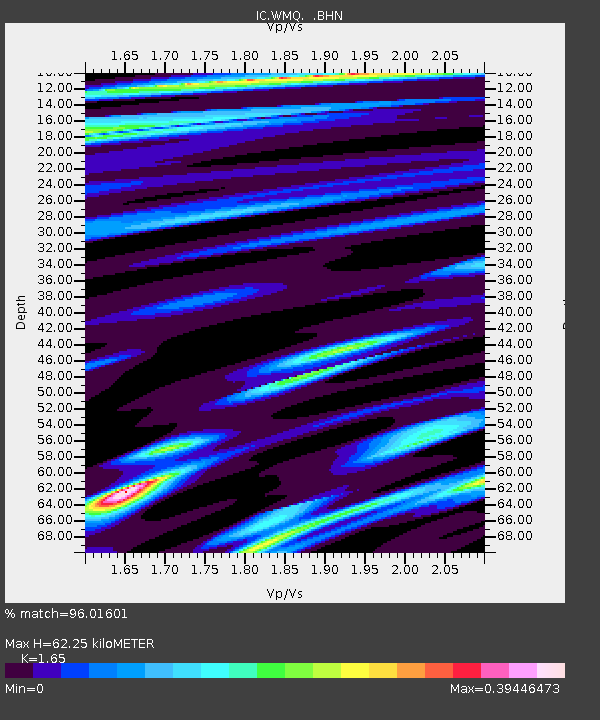
| Estimated Moho Depth: |
62.25 km |
| Estimated Crust Vp/Vs: |
1.65 |
| Assumed Crust Vp: |
6.242 km/s |
| Estimated Crust Vs: |
3.783 km/s |
| Estimated Crust Poisson's Ratio: |
0.21 |
|
| Radial Match: |
96.01601 % |
| Radial Bump: |
251 |
| Transverse Match: |
89.08729 % |
| Transverse Bump: |
400 |
| SOD ConfigId: |
4480 |
| Insert Time: |
2010-03-04 23:59:01.507 +0000 |
| GWidth: |
2.5 |
| Max Bumps: |
400 |
| Tol: |
0.001 |
|

Signal To Noise
| Channel | StoN | STA | LTA |
| IC:WMQ: :BHN:19990308T12:33:43.927012Z | 51.48681 | 5.3517397E-6 | 1.03943904E-7 |
| IC:WMQ: :BHE:19990308T12:33:43.927012Z | 18.477962 | 1.4706376E-6 | 7.958873E-8 |
| IC:WMQ: :BHZ:19990308T12:33:43.927012Z | 34.57646 | 2.3580826E-6 | 6.8199064E-8 |
| Arrivals |
| Ps | 6.9 SECOND |
| PpPs | 25 SECOND |
| PsPs/PpSs | 32 SECOND |


